
 Français
 Italiano
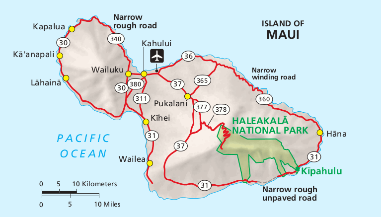
Pas de plus haute résolution disponible.
NPS_haleakala-maui-map.gif (767 × 437 pixels, taille du fichier : 55 kio, type MIME : image/gif, 0,1 s)
Description
| Description | English: Regional map of Haleakala and Maui. It shows where Haleakala is located in relation to other points of interest on the island of Maui. |
| Date | |
| Source | Haleakala National Park Maps (https://npmaps.com/haleakala) |
| Auteur | U.S. National Park Service, restoration/cleanup by National Park Maps (https://npmaps.com) |
| Autres versions |  |
Conditions d’utilisation
| Cette image ou ce document multimédia contient des éléments basés sur une œuvre d'un employé du National Park Service, créé dans le cadre des tâches officielles de cette personne. En tant qu'œuvre du Gouvernement fédéral des États-Unis, une telle œuvre se trouve dans le domaine public aux États-Unis. Voir NPS website et NPS copyright policy pour plus d'informations. |
Historique du fichier
Cliquer sur une date et heure pour voir le fichier tel qu'il était à ce moment-là.
| Date et heure | Vignette | Dimensions | Utilisateur | Commentaire | |
|---|---|---|---|---|---|
| actuel | 16 mai 2017 à 23:38 | | 767 × 437 (55 kio) | RKBot | =={{int:filedesc}}== {{Information |description= {{en|1=Regional map of Haleakala and Maui. It shows where Haleakala is located in relation to other points of interest on the island of Maui.}} |date= 2013-11-03 |source= U.S. National Park Service (http... |
Utilisation du fichier
Aucune page n’utilise ce fichier.
Usage global du fichier
Les autres wikis suivants utilisent ce fichier :
- Utilisation sur fr.wikipedia.org
Explore the world

United states
New York

Japan
Tokyo

Singapore
Singapore
