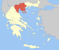
Taille de cet aperçu : 706 × 599 pixels. Autres résolutions : 283 × 240 pixels | 566 × 480 pixels.
Fichier d’origine (800 × 679 pixels, taille du fichier : 92 kio, type MIME : image/png)
Historique du fichier
Cliquer sur une date et heure pour voir le fichier tel qu'il était à ce moment-là.
| Date et heure | Vignette | Dimensions | Utilisateur | Commentaire | |
|---|---|---|---|---|---|
| actuel | 5 avril 2008 à 11:48 |  | 800 × 679 (92 kio) | Pitichinaccio | {{Information |Description=Locator Map of Central Makedonia Periphery, Greece |Source=eigene Arbeit |Date=April 5, 2008 |Author= Pitichinaccio }} {{PD-self}} Category:Periphery maps of Greece |
Utilisation du fichier
Aucune page n’utilise ce fichier.
Usage global du fichier
Les autres wikis suivants utilisent ce fichier :
- Utilisation sur ay.wikipedia.org
- Utilisation sur azb.wikipedia.org
- Utilisation sur az.wikipedia.org
- Utilisation sur ceb.wikipedia.org
- Utilisation sur da.wikipedia.org
- Utilisation sur de.wikipedia.org
- Utilisation sur en.wikipedia.org
- Thessaloniki
- Pella (regional unit)
- Serres
- Kilkis (regional unit)
- Central Macedonia
- Imathia
- Chalkidiki
- Pieria (regional unit)
- Katerini
- Polygyros
- Thessaloniki (regional unit)
- Serres (regional unit)
- Sithonia
- Kalamaria
- Giannitsa
- Alexandreia, Greece
- Naousa, Imathia
- Thermi
- Lagkadas
- Chalkidona
- Oraiokastro
- Skydra
- Edessa, Greece
- Visaltia
- Emmanouil Pappas (municipality)
- Irakleia, Serres
- Nea Zichni
- Kassandra, Chalkidiki
- Pella (municipality)
- Veria
- Almopia
- Sintiki
- Kilkis
- Template:Central Macedonia
- Aristotelis (municipality)
- Nea Propontida
- Paionia (municipality)
- Dion-Olympos
- Pydna-Kolindros
- Delta, Thessaloniki
- Ampelokipoi-Menemeni
- Kordelio-Evosmos
Voir davantage sur l’utilisation globale de ce fichier.


 Français
 Italiano


