
 Français
 Italiano
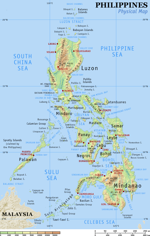
Taille de cet aperçu : 382 × 598 pixels. Autres résolutions : 153 × 240 pixels | 600 × 940 pixels.
Fichier d’origine (600 × 940 pixels, taille du fichier : 114 kio, type MIME : image/png)
Description
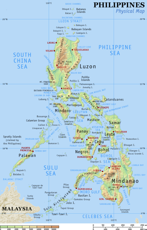
| Description | English: Physical map of the Philippines, showing all the major and some minor islands, bodies of water, mountains, and some major cities. |
| Date | |
| Source | Travail personnel |
| Auteur | Eugene Alvin Villar (seav) |
| Autres versions |
|


|
 | Cette image (de type carte) devrait être recréée dans un format vectoriel, en tant que fichier SVG. Cela offrirait plusieurs avantages : voir Commons:Media for cleanup pour plus d’informations. Si une version SVG de cette image est déjà disponible, merci de bien vouloir l’envoyer. Après cela, remplacez ce modèle par {{vector version available|nouveau nom d’image.svg}}. |
Conditions d’utilisation
Moi, en tant que détenteur des droits d’auteur sur cette œuvre, je la publie sous les licences suivantes :
Ce fichier est sous la licence Creative Commons Attribution – Partage dans les Mêmes Conditions 4.0 International.
- Vous êtes libre :
- de partager – de copier, distribuer et transmettre cette œuvre
- d’adapter – de modifier cette œuvre
- Sous les conditions suivantes :
- paternité – Vous devez donner les informations appropriées concernant l'auteur, fournir un lien vers la licence et indiquer si des modifications ont été faites. Vous pouvez faire cela par tout moyen raisonnable, mais en aucune façon suggérant que l’auteur vous soutient ou approuve l’utilisation que vous en faites.
- partage à l’identique – Si vous modifiez, transformez ou vous basez sur cet élément, vous devez distribuer votre contribution sous une license identique ou compatible à celle de l’original.
Ce fichier est disponible selon les termes de la licence Creative Commons Attribution – Partage dans les Mêmes Conditions 3.0 Non Transposé.
- Vous êtes libre :
- de partager – de copier, distribuer et transmettre cette œuvre
- d’adapter – de modifier cette œuvre
- Sous les conditions suivantes :
- paternité – Vous devez donner les informations appropriées concernant l'auteur, fournir un lien vers la licence et indiquer si des modifications ont été faites. Vous pouvez faire cela par tout moyen raisonnable, mais en aucune façon suggérant que l’auteur vous soutient ou approuve l’utilisation que vous en faites.
- partage à l’identique – Si vous modifiez, transformez ou vous basez sur cet élément, vous devez distribuer votre contribution sous une license identique ou compatible à celle de l’original.
 | Vous avez la permission de copier, distribuer et modifier ce document selon les termes de la GNU Free Documentation License version 1.2 ou toute version ultérieure publiée par la Free Software Foundation, sans sections inaltérables, sans texte de première page de couverture et sans texte de dernière page de couverture. Un exemplaire de la licence est inclus dans la section intitulée GNU Free Documentation License. |
Vous pouvez choisir l’une de ces licences.
Journal des téléversements d’origine
La page de description originale était ici. Tous les noms d'utilisateur qui suivent se rapportent à en.wikipedia.
| Date | User | File size | History log |
|---|---|---|---|
| 2005-08-29 15:09 | Riumplus | (117068 bytes) | Removed unused colours in the PNG palette, losslessly shrinking file size by 4% |
| 2004-07-25 09:09 | Guanaco | (121976 bytes) | optimize |
| 2003-08-17 08:46 | Seav | (122906 bytes) | Updated map with more details |
| 2003-06-20 11:13 | Seav | (130670 bytes) | Physical map of the Philippines. |
Historique du fichier
Cliquer sur une date et heure pour voir le fichier tel qu'il était à ce moment-là.
| Date et heure | Vignette | Dimensions | Utilisateur | Commentaire | |
|---|---|---|---|---|---|
| actuel | 1 mars 2007 à 22:05 | | 600 × 940 (114 kio) | Tene~commonswiki | Optimised (0) |
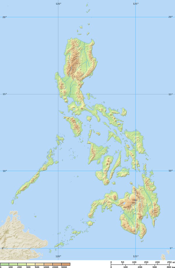
| 16 septembre 2005 à 17:21 |  | 600 × 940 (114 kio) | Saperaud~commonswiki | Physical map of the Philippines, showing all the major and some minor islands, bodies of water, mountains, and some major cities. See blank version which can be used for other language |
Utilisation du fichier
Aucune page n’utilise ce fichier.
Usage global du fichier
Les autres wikis suivants utilisent ce fichier :
- Utilisation sur af.wikipedia.org
- Utilisation sur an.wikipedia.org
- Utilisation sur ba.wikipedia.org
- Utilisation sur bg.wikipedia.org
- Utilisation sur bn.wikipedia.org
- Utilisation sur br.wikipedia.org
- Utilisation sur ca.wikipedia.org
- Utilisation sur cbk-zam.wikipedia.org
- Utilisation sur ceb.wikipedia.org
- Utilisation sur da.wikipedia.org
- Utilisation sur de.wikipedia.org
- Utilisation sur en.wikipedia.org
- User:Seav
- List of islands of the Philippines
- Template:Pic of the day/Archive1
- Ecoregions in the Philippines
- Wikipedia:Picture of the day/June 2004
- Manila Trench
- Wikipedia:Picture of the day/April 2005
- Wikipedia:POTD/April 13, 2005
- Wikipedia:Picture of the day/April 13, 2005
- User:Cyde/Featured pictures
- Wikipedia:Featured picture candidates/delist/2006
- Portal:Maps/Selected picture
- User talk:Howard the Duck/Archive3
- Wikipedia:Featured picture candidates/delist/2007
- Island groups of the Philippines
- Wikipedia:Featured picture candidates/delist/Ph physical map.png
- List of potentially active volcanoes in the Philippines
- User:Wittylama/FP Deletion
- Extreme points of the Philippines
- Portal:Maps/Selected picture/1
- Outline of the Philippines
- List of ultras of the Philippines
- List of active volcanoes in the Philippines
- List of inactive volcanoes in the Philippines
- Philippine Mobile Belt
- List of rivers of the Philippines
- Benham Rise
- Philippine fault system
- List of lighthouses in the Philippines
- Wikipedia:Featured picture candidates/delist/2010
- Marikina Valley fault system
- Wikipedia:Featured picture candidates/delist/File:Ph physical map.png
- List of mountains in the Philippines
- List of lakes of the Philippines
- List of protected areas of the Philippines
- List of bays of the Philippines
- List of headlands of the Philippines
Voir davantage sur l’utilisation globale de ce fichier.
Explore the world

United states
New York

Japan
Tokyo

Singapore
Singapore
