
 Français
 Italiano
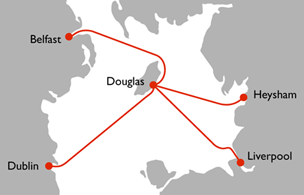
Pas de plus haute résolution disponible.
Steam_packet_route_map.png (304 × 195 pixels, taille du fichier : 24 kio, type MIME : image/png)
 | Une version vectorielle de cette image existe, dans le format « SVG ». Si elle n’est pas inférieure, elle devrait être utilisée à la place de la présente version pour des affichages en plus grandes dimensions ou nécessitant une meilleure résolution. File:Steam packet route map.png → File:Steam packet route map.svg Pour plus d’informations sur les images vectorielles, consultez la page de transition de Commons vers le format SVG. Voir aussi les informations à propos de la manière dont le logiciel MediaWiki gère les images au format SVG. |  |
Description
| Description | English: Map of the Irish Sea showing routes operated by the Isle of Man Steam Packet Company |
| Date | |
| Source | created by user: philphos |
| Auteur | created by user: philphos |
Conditions d’utilisation
| Moi, propriétaire des droits d’auteur sur cette œuvre, la place dans le domaine public. Ceci s'applique dans le monde entier. Dans certains pays, ceci peut ne pas être possible ; dans ce cas : J’accorde à toute personne le droit d’utiliser cette œuvre dans n’importe quel but, sans aucune condition, sauf celles requises par la loi. |
Historique du fichier
Cliquer sur une date et heure pour voir le fichier tel qu'il était à ce moment-là.
| Date et heure | Vignette | Dimensions | Utilisateur | Commentaire | |
|---|---|---|---|---|---|
| actuel | 28 mars 2010 à 13:49 | | 304 × 195 (24 kio) | Joe200576 | {{Information |Description={{en|1=Map of the Irish Sea showing routes operated by the Isle of Man Steam Packet Company}} |Source=created by user: philphos |Author=created by user: philphos |Date=2009-08-10 |Permission= |other_versions= }} |
Utilisation du fichier
Aucune page n’utilise ce fichier.
Usage global du fichier
Les autres wikis suivants utilisent ce fichier :
- Utilisation sur de.wikipedia.org
- Utilisation sur en.wikipedia.org
Explore the world

United states
New York

Japan
Tokyo

Singapore
Singapore
