
 Français
 Italiano
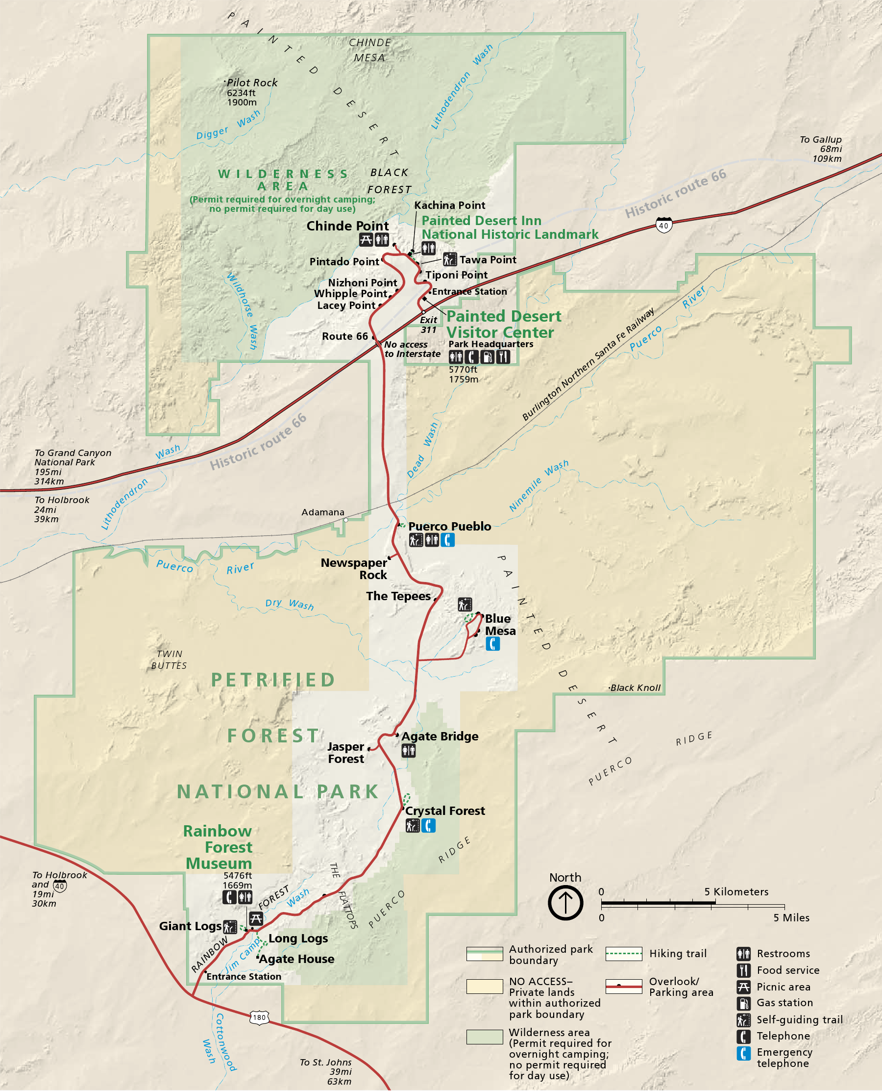
גודל התצוגה המקדימה הזאת: 485 × 600 פיקסלים. רזולוציות אחרות: 194 × 240 פיקסלים | 388 × 480 פיקסלים | 621 × 768 פיקסלים | 828 × 1,024 פיקסלים | 1,800 × 2,225 פיקסלים.
לקובץ המקורי (1,800 × 2,225 פיקסלים, גודל הקובץ: 1.69 מ"ב, סוג MIME: image/png)
זהו קובץ שמקורו במיזם ויקישיתוף. תיאורו בדף תיאור הקובץ המקורי (בעברית) מוצג למטה ויקישיתוף הוא מאגר תמונות וקובצי מדיה חופשיים. אתם יכולים לעזור. |
תקציר
| תיאור | English: Map of Petrified Forest National Park — in northeastern Arizona, United States.
|
| תאריך יצירה | |
| מקור | official park map |
| יוצר | National Park Service; converted from PDF to PNG format by User:Finetooth using GNU Image Manipulation Program (GIMP) software |
רישיון
| This image or media file contains material based on a work of a National Park Service employee, created as part of that person's official duties. As a work of the U.S. federal government, such work is in the public domain in the United States. See the NPS website and NPS copyright policy for more information. |
היסטוריית הקובץ
ניתן ללחוץ על תאריך/שעה כדי לראות את הקובץ כפי שנראה באותו זמן.
| תאריך/שעה | תמונה ממוזערת | ממדים | משתמש | הערה | |
|---|---|---|---|---|---|
| נוכחית | 23:41, 28 באוקטובר 2010 | | 2,225 × 1,800 (1.69 מ"ב) | Finetooth | {{Information |Description={{en|1=Map of Petrified Forest National Park in northeastern Arizona, United States}} |Source=National Park Service [http://www.nps.gov/pefo/planyourvisit/maps.htm maps] |Au |
שימוש בקובץ
אין דפים המשתמשים בקובץ זה.
שימוש גלובלי בקובץ
אתרי הוויקי האחרים הבאים משתמשים בקובץ הזה:
- שימוש באתר da.wikipedia.org
- שימוש באתר de.wikipedia.org
- שימוש באתר de.wikivoyage.org
- שימוש באתר en.wikipedia.org
- שימוש באתר eu.wikipedia.org
- שימוש באתר he.wikipedia.org
- שימוש באתר it.wikipedia.org
- שימוש באתר nl.wikipedia.org
- שימוש באתר pl.wikipedia.org
- שימוש באתר pt.wikipedia.org
- שימוש באתר tr.wikipedia.org
- שימוש באתר vi.wikipedia.org
Explore the world

United states
New York

Japan
Tokyo

Singapore
Singapore
