
 Français
 Italiano
גודל התצוגה המקדימה הזאת: 600 × 600 פיקסלים. רזולוציות אחרות: 240 × 240 פיקסלים | 480 × 480 פיקסלים.
לקובץ המקורי (800 × 800 פיקסלים, גודל הקובץ: 393 ק"ב, סוג MIME: image/png)
זהו קובץ שמקורו במיזם ויקישיתוף. תיאורו בדף תיאור הקובץ המקורי (בעברית) מוצג למטה ויקישיתוף הוא מאגר תמונות וקובצי מדיה חופשיים. אתם יכולים לעזור. |
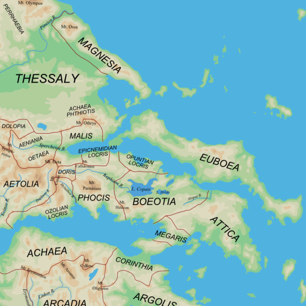
| תיאור | English: Map of the central regions of Ancient Greece |
| תאריך יצירה | (UTC) |
| מקור |
|
| יוצר | User:MinisterForBadTimes |
| גרסאות אחרות | Derivative works of this file: |
| זוהי תמונה מרוטשת, זאת אומרת שהתמונה שונתה בצורה דיגיטלית מהמקור. את התמונה המקורית ניתן לראות ב: Ancient Greek southern regions.png. השינוי בוצע על ידי MinisterForBadTimes.
|
אני, בעל זכויות היוצרים על היצירה הזאת, מפרסם אותה בזאת תחת הרישיונות הבאים:
הקובץ הזה מתפרסם לפי תנאי רישיון קריאייטיב קומונז ייחוס-שיתוף זהה 2.5 כללי.
- יש לך חופש:
- לשתף – להעתיק, להפיץ ולהעביר את העבודה
- לערבב בין עבודות – להתאים את העבודה
- תחת התנאים הבאים:
- ייחוס – יש לתת ייחוס הולם, לתת קישור לרישיון, ולציין אם נעשו שינויים. אפשר לעשות את זה בכל צורה סבירה, אבל לא בשום צורה שמשתמע ממנה שמעניק הרישיון תומך בך או בשימוש שלך.
- שיתוף זהה – יצירת רמיקס, שינוי או בנייה על סמך החומר הזה, תטיל עליך חובה להפיץ את התרומות שלך לפי תנאי רישיון זהה או תואם למקור.
| הקובץ הזה מתפרסם לפי תנאי רישיון קריאייטיב קומונז ייחוס-שיתוף זהה 3.0 לא מותאם. | ||
| ||
| תבנית רישוי זו הוספה לקובץ כחלק מעדכון רישיון GFDL. |
 | מוענקת בכך הרשות להעתיק, להפיץ או לשנות את המסמך הזה, לפי תנאי הרישיון לשימוש חופשי במסמכים של גנו, גרסה 1.2 או כל גרסה מאוחרת יותר שתפורסם על־ידי המוסד לתוכנה חופשית; ללא פרקים קבועים, ללא טקסט עטיפה קדמית וללא טקסט עטיפה אחורית. עותק של הרישיון כלול בפרק שכותרתו הרישיון לשימוש חופשי במסמכים של גנו. |
אפשר לבחור את הרישיון שמתאים לך.
יומן העלאה מקורי
This image is a derivative work of the following images:
- File:Ancient_Greek_southern_regions.png licensed with Cc-by-sa-2.5, Cc-by-sa-3.0-migrated, GFDL
- 2010-01-12T08:44:56Z MinisterForBadTimes 800x800 (385822 Bytes) {{Information |Description={{en|Map of the regions of Ancient Greece}} |Source=*[[:File:Map_greek_sanctuaries-en.svg|]]. Geographical information based on public domain map of Greece, from the Perry-Castañeda Library Map Col
Uploaded with derivativeFX
היסטוריית הקובץ
ניתן ללחוץ על תאריך/שעה כדי לראות את הקובץ כפי שנראה באותו זמן.
| תאריך/שעה | תמונה ממוזערת | ממדים | משתמש | הערה | |
|---|---|---|---|---|---|
| נוכחית | 23:41, 3 במרץ 2010 | | 800 × 800 (393 ק"ב) | MinisterForBadTimes | Two spellings corrected |
| 00:44, 2 במרץ 2010 |  | 800 × 800 (393 ק"ב) | MinisterForBadTimes | {{Information |Description={{en|Map of the central regions of Ancient Greece}} |Source=*blank(ish) map from Ancient_Greek_southern_regions.png, ultimately derived from [[:File:Map_greek_sanctuaries-en.svg|Map_g |
שימוש בקובץ
אין דפים המשתמשים בקובץ זה.
שימוש גלובלי בקובץ
אתרי הוויקי האחרים הבאים משתמשים בקובץ הזה:
- שימוש באתר azb.wikipedia.org
- שימוש באתר bg.wikipedia.org
- שימוש באתר cs.wikipedia.org
- שימוש באתר de.wikipedia.org
- שימוש באתר el.wikipedia.org
- שימוש באתר en.wikipedia.org
- שימוש באתר eo.wikipedia.org
- שימוש באתר et.wikipedia.org
- שימוש באתר fi.wikipedia.org
- שימוש באתר fr.wikipedia.org
- שימוש באתר hu.wikipedia.org
- שימוש באתר id.wikipedia.org
- שימוש באתר it.wikipedia.org
- שימוש באתר ja.wikipedia.org
- שימוש באתר ja.wikibooks.org
- שימוש באתר la.wikipedia.org
- שימוש באתר ms.wikipedia.org
- שימוש באתר nn.wikipedia.org
- שימוש באתר pl.wiktionary.org
- שימוש באתר pnb.wikipedia.org
- שימוש באתר ru.wikipedia.org
- שימוש באתר sl.wikipedia.org
- שימוש באתר sq.wikipedia.org
- שימוש באתר tr.wikipedia.org
צפייה בשימושים גלובליים נוספים של הקובץ הזה.
Explore the world

United states
New York

Japan
Tokyo

Singapore
Singapore
