
 Français
 Italiano
לקובץ המקורי (קובץ SVG, הגודל המקורי: 998 × 789 פיקסלים, גודל הקובץ: 724 ק"ב)
זהו קובץ שמקורו במיזם ויקישיתוף. תיאורו בדף תיאור הקובץ המקורי (בעברית) מוצג למטה ויקישיתוף הוא מאגר תמונות וקובצי מדיה חופשיים. אתם יכולים לעזור. |
תקציר
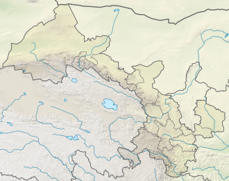
| תיאור | Deutsch: Positionskarte von Gansu, Volksrepublik China English: Location map of Gansu, People's Republic of China
| ||||||||||||
| תאריך יצירה | |||||||||||||
| מקור | נוצר על ידי מעלה היצירה, תוך שימוש:
| ||||||||||||
| יוצר | NordNordWest | ||||||||||||
| גרסאות אחרות | | ||||||||||||

 | This map has been made or improved in the German Kartenwerkstatt (Map Lab). You can propose maps to improve as well. |
רישיון
Usage of this file with:

explanatory notes: Legally binding is only the full legalcode. For a free usage I recommend to respect the following licence conditions:
1. Provide my name as given above: NordNordWest,
2. a copy of, or the URI for, the applicable license: https://creativecommons.org/licenses/by-sa/3.0/de/legalcode,
3. the title of the work,
4. in the case of an adaptation, a credit identifying the use of the work in the adaptation.
This license and the rights granted hereunder will terminate automatically upon any breach by you of the terms of this license. Any of the above conditions can be waived if you get permission from the copyright holder. If you have questions or wish differing conditions, please contact me through nnwest or my discussion page ![]() t-online.de
t-online.de
- יש לך חופש:
- לשתף – להעתיק, להפיץ ולהעביר את העבודה
- לערבב בין עבודות – להתאים את העבודה
- תחת התנאים הבאים:
- ייחוס – יש לתת ייחוס הולם, לתת קישור לרישיון, ולציין אם נעשו שינויים. אפשר לעשות את זה בכל צורה סבירה, אבל לא בשום צורה שמשתמע ממנה שמעניק הרישיון תומך בך או בשימוש שלך.
- שיתוף זהה – יצירת רמיקס, שינוי או בנייה על סמך החומר הזה, תטיל עליך חובה להפיץ את התרומות שלך לפי תנאי רישיון זהה או תואם למקור.

היסטוריית הקובץ
ניתן ללחוץ על תאריך/שעה כדי לראות את הקובץ כפי שנראה באותו זמן.
| תאריך/שעה | תמונה ממוזערת | ממדים | משתמש | הערה | |
|---|---|---|---|---|---|
| נוכחית | 20:49, 24 באפריל 2022 | | 789 × 998 (724 ק"ב) | NordNordWest | == {{int:filedesc}} == {{Information |Description= {{de|1=Positionskarte von Gansu, Volksrepublik China}} {{en|1=Location map of Gansu, People's Republic of China}} {{Location map series N |stretching=126 |top=43 |bottom=32.4 |left=92.1 |right=109 }} |Source={{Own using}} * United States National Imagery and Mapping Agency data * World Data Base II data * ETOPO1 data |Date=2022-04-24 |Author={{U|NordNordWest}} |Permission= |other_versions=<gallery>China Gansu adm location map.svg</gallery> }}... |
שימוש בקובץ
אין דפים המשתמשים בקובץ זה.
שימוש גלובלי בקובץ
אתרי הוויקי האחרים הבאים משתמשים בקובץ הזה:
- שימוש באתר bn.wikipedia.org
- שימוש באתר de.wikipedia.org
- שימוש באתר en.wikipedia.org
- Dunhuang
- Mogao Caves
- Yumen City
- Crescent Lake (Dunhuang)
- Zhangye
- Lintao County
- Wushao Mountain
- Hekou Group
- Liujiaxia Reservoir
- 2010 Gansu mudslide
- Lazikou Pass
- Battle of Mount Qi
- 1879 Gansu earthquake
- Module:Location map/data/China Gansu
- Module:Location map/data/China Gansu/doc
- User:Ty654/List of earthquakes from 1900-1949 exceeding magnitude 7+
- User:Ty654/List of earthquakes from 1950-1999 exceeding magnitude 7+
- User:Ty654/List of earthquakes from 1920-1929 exceeding magnitude 6+
- User:Ty654/List of earthquakes from 1930-1939 exceeding magnitude 6+
- User:Ty654/List of earthquakes from 1950-1954 exceeding magnitude 6+
- Suoyang City
- User:Ty654/List of earthquakes before 1900 exceeding magnitude 8+
- Baishiya Karst Cave
- Module:Location map/data/Gansu
- Donggang Subdistrict
- Dahe Township, Gansu
- Zhuanglang River
- 1718 Tongwei–Gansu earthquake
- Module:Location map/data/Gansu/doc
- 2023 Jishishan earthquake
- שימוש באתר eo.wikipedia.org
- שימוש באתר es.wikipedia.org
צפייה בשימושים גלובליים נוספים של הקובץ הזה.
מטא־נתונים
Explore the world

United states
New York

Japan
Tokyo

Singapore
Singapore
