
 Français
 Italiano
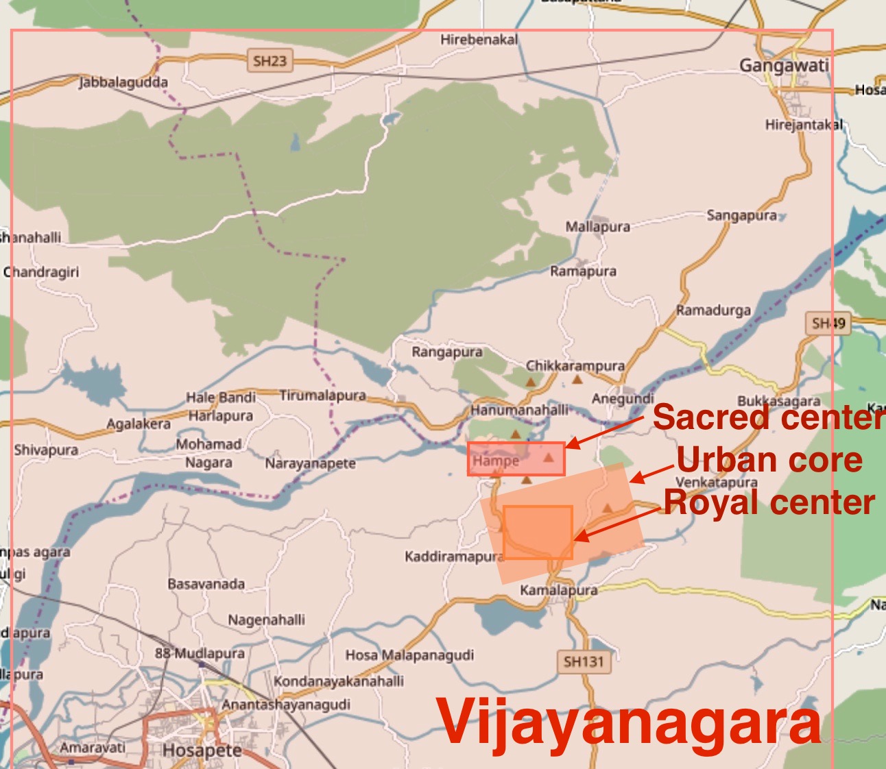
לקובץ המקורי (1,292 × 1,122 פיקסלים, גודל הקובץ: 277 ק"ב, סוג MIME: image/jpeg)
זהו קובץ שמקורו במיזם ויקישיתוף. תיאורו בדף תיאור הקובץ המקורי (בעברית) מוצג למטה ויקישיתוף הוא מאגר תמונות וקובצי מדיה חופשיים. אתם יכולים לעזור. |
תקציר
| תיאור | English: This is a derivative work on OpenStreet map available under Creative Commons 2.0 license, as downloaded on October 13 2017. Source: http://www.openstreetmap.org/ Authors of the raw map: OpenStreetMap contributors Note: This map was created from OpenStreetMap project data, collected by the community. This map may be incomplete, and may contain errors. Don't rely solely on it for navigation or scholarship. The markings and other information are approximate. The image shows the Hampi sacred center, the urban core and royal center, as well as the spread of Vijayanagara metropolis suburbs around the urban core. Archaeological surveys and excavations have located Vijayanagara ruins from Gangawati in northeast to Hosapete in southwest. For example, the Anantashayana Gudi is found in Hosapete. Many residential areas were closer to the urban core. According to scholars, Vijayanagara was the second largest city in the world, after Beijing, in early 16th century. The city was destroyed in 1565 CE and most of it remained in ruins since then. |
| תאריך יצירה | |
| מקור | נוצר על־ידי מעלה היצירה |
| יוצר | Ms Sarah Welch |
רישיון
- יש לך חופש:
- לשתף – להעתיק, להפיץ ולהעביר את העבודה
- לערבב בין עבודות – להתאים את העבודה
- תחת התנאים הבאים:
- ייחוס – יש לתת ייחוס הולם, לתת קישור לרישיון, ולציין אם נעשו שינויים. אפשר לעשות את זה בכל צורה סבירה, אבל לא בשום צורה שמשתמע ממנה שמעניק הרישיון תומך בך או בשימוש שלך.
- שיתוף זהה – יצירת רמיקס, שינוי או בנייה על סמך החומר הזה, תטיל עליך חובה להפיץ את התרומות שלך לפי תנאי רישיון זהה או תואם למקור.
היסטוריית הקובץ
ניתן ללחוץ על תאריך/שעה כדי לראות את הקובץ כפי שנראה באותו זמן.
| תאריך/שעה | תמונה ממוזערת | ממדים | משתמש | הערה | |
|---|---|---|---|---|---|
| נוכחית | 00:55, 14 באוקטובר 2017 | | 1,122 × 1,292 (277 ק"ב) | Ms Sarah Welch | User created page with UploadWizard |
שימוש בקובץ
אין דפים המשתמשים בקובץ זה.
שימוש גלובלי בקובץ
אתרי הוויקי האחרים הבאים משתמשים בקובץ הזה:
מטא־נתונים
Explore the world

United states
New York

Japan
Tokyo

Singapore
Singapore
