
 Français
 Italiano
גודל התצוגה המקדימה הזאת: 778 × 600 פיקסלים. רזולוציות אחרות: 311 × 240 פיקסלים | 623 × 480 פיקסלים | 996 × 768 פיקסלים | 1,104 × 851 פיקסלים.
לקובץ המקורי (1,104 × 851 פיקסלים, גודל הקובץ: 505 ק"ב, סוג MIME: image/jpeg)
זהו קובץ שמקורו במיזם ויקישיתוף. תיאורו בדף תיאור הקובץ המקורי (בעברית) מוצג למטה ויקישיתוף הוא מאגר תמונות וקובצי מדיה חופשיים. אתם יכולים לעזור. |
תקציר
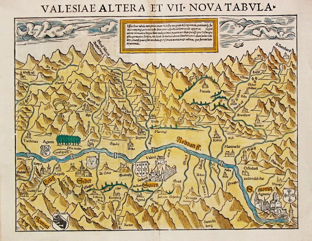
| תיאור | English: Oldest known map of the Valais, drawn by Johannes Schalbetter, printed by Sebastian Münster in Basel, 1545–1552. 26.0 x 34.0 cm. Blumer, Bibliographie der Gesamtkarten der Schweiz, entry 23. The map faces south. It only shows the central portion of the Valais, from Leuk to Saint-Maurice, cutting off the Upper Valais communes of Goms, Brig, Visp and Raron. The Matterhorn is prominently labelled Mons Silvius / Augstal berg. The Great St Bernard Pass is shown top right, the Gemmi Pass bottom left.
|
| תאריך יצירה | |
| מקור | print by Sebastian Münster. Immediate source: swaen.com |
| יוצר | Johannes Schalbetter, Sebastian Münster |
רישיון
| יצירה זו נמצאת בנחלת הכלל במדינת המקור ובמדינות אחרות בהם תקופת זכויות היוצרים היא משך חיי היוצר ו-100 שנה (או פחות) מפטירתו. | |
| הקובץ הזה זוהה כקובץ חופשי מכל מגבלה ידועה תחת חוק זכויות היוצרים, כולל כל הזכויות הקשורות והסמוכות. | |
היסטוריית הקובץ
ניתן ללחוץ על תאריך/שעה כדי לראות את הקובץ כפי שנראה באותו זמן.
| תאריך/שעה | תמונה ממוזערת | ממדים | משתמש | הערה | |
|---|---|---|---|---|---|
| נוכחית | 10:27, 7 ביולי 2017 | | 851 × 1,104 (505 ק"ב) | Dbachmann | {{Information |Description ={{en|1=Oldest known map of the Valais.}} |Source =print by Sebastian Münster. Immediate source: [http://www.swaen.com/antique-map-of.php?id=8122 swaen.com] |Author =Johannes Schalbetter, Sebastian Münste... |
שימוש בקובץ
אין דפים המשתמשים בקובץ זה.
שימוש גלובלי בקובץ
אתרי הוויקי האחרים הבאים משתמשים בקובץ הזה:
- שימוש באתר en.wikipedia.org
Explore the world

United states
New York

Japan
Tokyo

Singapore
Singapore
