
 Français
 Italiano
גודל התצוגה המקדימה הזאת: 560 × 599 פיקסלים. רזולוציות אחרות: 224 × 240 פיקסלים | 448 × 480 פיקסלים | 718 × 768 פיקסלים | 957 × 1,024 פיקסלים | 1,914 × 2,048 פיקסלים | 4,597 × 4,920 פיקסלים.
לקובץ המקורי (4,597 × 4,920 פיקסלים, גודל הקובץ: 6 מ"ב, סוג MIME: image/jpeg)
זהו קובץ שמקורו במיזם ויקישיתוף. תיאורו בדף תיאור הקובץ המקורי (בעברית) מוצג למטה ויקישיתוף הוא מאגר תמונות וקובצי מדיה חופשיים. אתם יכולים לעזור. |
תקציר
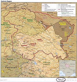
| תיאור | English: The disputed Kashmir region, showing the sub-regions administered by India, Pakistan, and China |
| תאריך יצירה | |
| מקור | https://upload.wikimedia.org/wikipedia/commons/8/8f/Kashmir_region._LOC_2003626427.jpg |
| יוצר | US Central Intelligence Agency (old labels removed, new added by Fowler&fowler (שיחה) 02:56, 11 April 2022 (UTC)) |
| גרסאות אחרות |  |
רישיון
This work is in the public domain in the United States because it is a work prepared by an officer or employee of the United States Government as part of that person’s official duties under the terms of Title 17, Chapter 1, Section 105 of the US Code. Note: This only applies to original works of the Federal Government and not to the work of any individual U.S. state, territory, commonwealth, county, municipality, or any other subdivision. This template also does not apply to postage stamp designs published by the United States Postal Service since 1978. (See § 313.6(C)(1) of Compendium of U.S. Copyright Office Practices). It also does not apply to certain US coins; see The US Mint Terms of Use. |  | |
| הקובץ הזה זוהה כקובץ חופשי מכל מגבלה ידועה תחת חוק זכויות היוצרים, כולל כל הזכויות הקשורות והסמוכות. | ||
היסטוריית הקובץ
ניתן ללחוץ על תאריך/שעה כדי לראות את הקובץ כפי שנראה באותו זמן.
| תאריך/שעה | תמונה ממוזערת | ממדים | משתמש | הערה | |
|---|---|---|---|---|---|
| נוכחית | 05:31, 4 ביולי 2023 | | 4,920 × 4,597 (6 מ"ב) | Fowler&fowler | Reverted to version as of 14:18, 12 April 2022 (UTC) |
| 17:46, 24 ביוני 2023 |  | 4,920 × 4,597 (3.74 מ"ב) | Geographyinitiative | There is no evidence that Demchok sector is part of Aksai Chin. The original map is good enough and the yellow scribbles attempt to steal the authority of the professional cartographers. | |
| 17:18, 12 באפריל 2022 |  | 4,920 × 4,597 (6 מ"ב) | Fowler&fowler | Added Peaks | |
| 05:56, 11 באפריל 2022 |  | 4,920 × 4,597 (6 מ"ב) | Fowler&fowler | Uploaded a work by US Central Intelligence Agency (old labels removed, new added by ~~~~) from https://upload.wikimedia.org/wikipedia/commons/8/8f/Kashmir_region._LOC_2003626427.jpg with UploadWizard |
שימוש בקובץ
אין דפים המשתמשים בקובץ זה.
שימוש גלובלי בקובץ
אתרי הוויקי האחרים הבאים משתמשים בקובץ הזה:
- שימוש באתר ar.wikipedia.org
- שימוש באתר as.wikipedia.org
- שימוש באתר bn.wikipedia.org
- שימוש באתר el.wikipedia.org
- שימוש באתר en.wikipedia.org
- Azad Kashmir
- Kashmir
- Aksai Chin
- Ladakh
- Gilgit
- Skardu
- Muzaffarabad
- Mirpur, Azad Kashmir
- Bagh District
- Bhimber District
- Kotli District
- Muzaffarabad District
- Mirpur District
- Insurgency in Jammu and Kashmir
- Operation Tupac
- Kashmir conflict
- Leh district
- Kargil
- India–Pakistan relations
- Chilas
- Ghanche District
- Skardu District
- Gilgit District
- Diamer District
- Astore District
- Neelum District
- Jammu and Kashmir (princely state)
- Gilgit-Baltistan
- Haveli District
- Hattian Bala District
- Nagar District
- Roundu District
- Shigar District
- Kharmang District
- Hunza District
- Gilgit Division
- Baltistan Division
- Diamer Division
- Gupis-Yasin District
- Jammu and Kashmir (union territory)
- Revocation of the special status of Jammu and Kashmir
- Darel District
- Ghizer District (2019–)
צפייה בשימושים גלובליים נוספים של הקובץ הזה.
מטא־נתונים
Explore the world

United states
New York

Japan
Tokyo

Singapore
Singapore
