
 Français
 Italiano
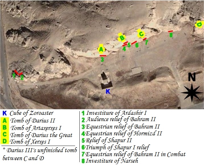
אין גרסה ברזולוציה גבוהה יותר.
Map_of_Naqsh-e_Rostam.jpg (717 × 579 פיקסלים, גודל הקובץ: 179 ק"ב, סוג MIME: image/jpeg)
זהו קובץ שמקורו במיזם ויקישיתוף. תיאורו בדף תיאור הקובץ המקורי (בעברית) מוצג למטה ויקישיתוף הוא מאגר תמונות וקובצי מדיה חופשיים. אתם יכולים לעזור. |
תקציר
| תיאור | map of archeological site of Naqsh-e Rostam (Iran, fars Province, city of Marvdasht) |
| תאריך יצירה | |
| מקור | Own work using NASA's satellite picture of the place and an artifact sheme according to belgium archeologist Louis Vanden Berghe. |
| יוצר | Pentocelo |
| גרסאות אחרות | with french legends Image:Map of Naqsh-e Rostam (fr).jpg |
.jpg)
רישיון
| ברצוני, בעלי זכויות היוצרים על יצירה זו, לשחרר יצירה זו לנחלת הכלל. זה תקף בכל העולם. יש מדינות שבהן הדבר אינו אפשרי על פי חוק, אם כך: אני מעניק לכל אחד את הזכות להשתמש בעבודה זו לכל מטרה שהיא, ללא תנאים כלשהם, אלא אם כן תנאים כאלה נדרשים על פי חוק. |
היסטוריית הקובץ
ניתן ללחוץ על תאריך/שעה כדי לראות את הקובץ כפי שנראה באותו זמן.
| תאריך/שעה | תמונה ממוזערת | ממדים | משתמש | הערה | |
|---|---|---|---|---|---|
| נוכחית | 07:56, 27 בפברואר 2011 | | 579 × 717 (179 ק"ב) | Dr. Persi | I took this file from the original work done by the User Pentocelo. This is his original work and therefore the credit belongs to him. He however uploaded the file as no copyright, enabling me to improve his original version. He has created two versions o |
| 22:58, 6 בפברואר 2008 |  | 579 × 717 (75 ק"ב) | Pentocelo~commonswiki | == Description == {{Information |Description= map of archeological site of Naqsh-e Rostam (Iran, fars Province, city of Marvdasht) |Source= Own work using NASA's satellite picture of the place and an artifact sheme according to belgium archeologist Louis | |
| 22:26, 6 בפברואר 2008 |  | 624 × 721 (83 ק"ב) | Pentocelo~commonswiki | {{Information |Description= map of archeological site of Naqsh-e Rostam (Iran, fars Province, city of Marvdasht) |Source= Own work using NASA's satellite picture of the place and an artifact sheme according to belgium archeologist Louis Vanden Berghe. |Da |
שימוש בקובץ
אין דפים המשתמשים בקובץ זה.
שימוש גלובלי בקובץ
אתרי הוויקי האחרים הבאים משתמשים בקובץ הזה:
- שימוש באתר ca.wikipedia.org
- שימוש באתר de.wikivoyage.org
- שימוש באתר en.wikipedia.org
- שימוש באתר es.wikipedia.org
- שימוש באתר it.wikipedia.org
- שימוש באתר sl.wikipedia.org
- שימוש באתר vi.wikipedia.org
מטא־נתונים
Explore the world

United states
New York

Japan
Tokyo

Singapore
Singapore
