
 Français
 Italiano
גודל התצוגה המקדימה הזאת מסוג PNG של קובץ ה־SVG הזה: 586 × 599 פיקסלים. רזולוציות אחרות: 235 × 240 פיקסלים | 469 × 480 פיקסלים | 751 × 768 פיקסלים | 1,001 × 1,024 פיקסלים | 2,002 × 2,048 פיקסלים | 923 × 944 פיקסלים.
לקובץ המקורי (קובץ SVG, הגודל המקורי: 923 × 944 פיקסלים, גודל הקובץ: 374 ק"ב)
זהו קובץ שמקורו במיזם ויקישיתוף. תיאורו בדף תיאור הקובץ המקורי (בעברית) מוצג למטה ויקישיתוף הוא מאגר תמונות וקובצי מדיה חופשיים. אתם יכולים לעזור. |
W3C-validity not checked.
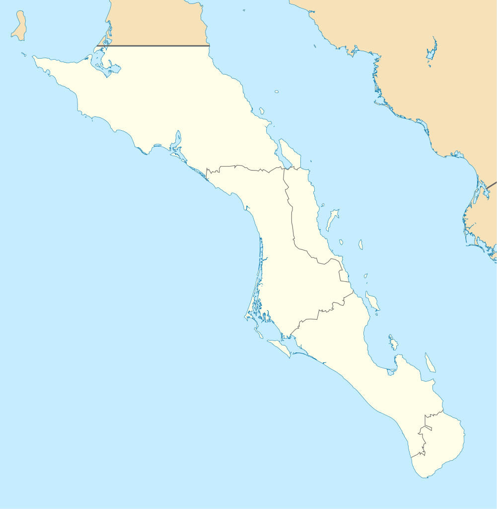
| תיאור | English: Own work as from the map of municipalities of INEGI and costs taken from OpenStreetMap.org (under Creative Commons Attribution-Share Alike 2.0 Generic Licence). Limits of map:
Español: Trabajo propio a partir del mapa de municipios del INEGI y costas tomadas de OpenStreetMap.org (bajo licencia Creative Commons Attribution-Share Alike 2.0 Generic). |
| תאריך יצירה | (UTC) |
| מקור | |
| יוצר |
|
| זוהי תמונה מרוטשת, זאת אומרת שהתמונה שונתה בצורה דיגיטלית מהמקור. Modifications: Changed color of other states, removed black line. את התמונה המקורית ניתן לראות ב: Baja California Sur Location Map.svg. השינוי בוצע על ידי Spischot.
|
אני, בעל זכויות היוצרים על היצירה הזאת, מפרסם אותה בזאת תחת הרישיונות הבאים:
הקובץ הזה מתפרסם לפי תנאי רישיונות קריאייטיב קומונז ייחוס-שיתוף זהה 3.0 לא מותאם, 2.5 כללי, 2.0 כללי ו־1.0 כללי.
- יש לך חופש:
- לשתף – להעתיק, להפיץ ולהעביר את העבודה
- לערבב בין עבודות – להתאים את העבודה
- תחת התנאים הבאים:
- ייחוס – יש לתת ייחוס הולם, לתת קישור לרישיון, ולציין אם נעשו שינויים. אפשר לעשות את זה בכל צורה סבירה, אבל לא בשום צורה שמשתמע ממנה שמעניק הרישיון תומך בך או בשימוש שלך.
- שיתוף זהה – יצירת רמיקס, שינוי או בנייה על סמך החומר הזה, תטיל עליך חובה להפיץ את התרומות שלך לפי תנאי רישיון זהה או תואם למקור.
 | מוענקת בכך הרשות להעתיק, להפיץ או לשנות את המסמך הזה, לפי תנאי הרישיון לשימוש חופשי במסמכים של גנו, גרסה 1.2 או כל גרסה מאוחרת יותר שתפורסם על־ידי המוסד לתוכנה חופשית; ללא פרקים קבועים, ללא טקסט עטיפה קדמית וללא טקסט עטיפה אחורית. עותק של הרישיון כלול בפרק שכותרתו הרישיון לשימוש חופשי במסמכים של גנו. |
אפשר לבחור את הרישיון שמתאים לך.
יומן העלאה מקורי
This image is a derivative work of the following images:
- File:Baja_California_Sur_Location_Map.svg licensed with Cc-by-sa-3.0,2.5,2.0,1.0, GFDL
- 2009-09-02T20:36:30Z Addicted04 923x944 (371328 Bytes) cost line
- 2009-08-19T23:25:40Z Addicted04 923x944 (371198 Bytes) line in the top
- 2009-08-19T22:51:13Z Addicted04 923x944 (370920 Bytes) {{Information |Description={{en|1=Own work as from the map of municipalities of INEGI and costs taken from OpenStreetMap.org (under Creative Commons Attribution-Share Alike 2.0 Generic Licence). Limits of map: * West : 115º
Uploaded with derivativeFX
היסטוריית הקובץ
ניתן ללחוץ על תאריך/שעה כדי לראות את הקובץ כפי שנראה באותו זמן.
| תאריך/שעה | תמונה ממוזערת | ממדים | משתמש | הערה | |
|---|---|---|---|---|---|
| נוכחית | 22:32, 7 באוגוסט 2011 | | 944 × 923 (374 ק"ב) | Addicted04 | color |
| 22:28, 7 באוגוסט 2011 |  | 944 × 923 (374 ק"ב) | Battroid | {{ValidSVG}} {{Information |Description={{en|1=Own work as from the map of municipalities of INEGI and costs taken from OpenStreetMap.org (under Creative Commons Attribution-Share Alike 2.0 Generic Licence). Limits of map: * West : 115.50' W * Est : 109. | |
| 00:36, 28 באוקטובר 2009 |  | 944 × 923 (374 ק"ב) | Spischot | Fix: Isla de Cedros to Baja California | |
| 00:12, 28 באוקטובר 2009 |  | 944 × 923 (363 ק"ב) | Spischot | {{Information |Description={{en|1=Own work as from the map of municipalities of INEGI and costs taken from OpenStreetMap.org (under Creative Commons Attribution-Share Alike 2.0 Generic Licence). Limits of map: * West : 115º 5' W * Est : 109º W * Nort |
שימוש בקובץ
אין דפים המשתמשים בקובץ זה.
שימוש גלובלי בקובץ
אתרי הוויקי האחרים הבאים משתמשים בקובץ הזה:
- שימוש באתר ar.wikipedia.org
- שימוש באתר ba.wikipedia.org
- שימוש באתר bg.wikipedia.org
- שימוש באתר ceb.wikipedia.org
- שימוש באתר ce.wikipedia.org
- שימוש באתר cs.wikipedia.org
- שימוש באתר de.wikipedia.org
- La Paz (Baja California Sur)
- Loreto (Baja California Sur)
- Guerrero Negro
- Mulegé
- San Ignacio (Baja California Sur)
- Isla Espíritu Santo
- Isla Santa Catalina (Mexiko)
- Santa Rosalía
- Benutzer:Spischot/Bilder
- Aguajito
- Wikipedia:Kartenwerkstatt/Positionskarten/Nordamerika
- Cabo San Lucas
- San Bruno (Baja California Sur)
- Todos Santos (Mexiko)
- Isla Santa Margarita
- Vorlage:Positionskarte Mexiko Baja California Sur
- Tortuga (Mexiko)
- Isla Natividad
- Isla Carmen
- Isla Monserrat
- Isla Coronados
- Isla San Marcos
- Isla Santa Cruz (Mexiko)
- Isla San Diego
- Isla Danzante
- Isla San Francisco
- Bahía Magdalena
- San José del Cabo
- Nationalpark Cabo Pulmo
- Estadio Guaycura
- Ciudad Constitución (Mexiko)
- שימוש באתר en.wikipedia.org
צפייה בשימושים גלובליים נוספים של הקובץ הזה.
מטא־נתונים
Explore the world

United states
New York

Japan
Tokyo

Singapore
Singapore
