לקובץ המקורי (קובץ SVG, הגודל המקורי: 250 × 251 פיקסלים, גודל הקובץ: 905 ק"ב)

הצגת תמונה זו בשפה .
זהו קובץ שמקורו במיזם ויקישיתוף. תיאורו בדף תיאור הקובץ המקורי (בעברית) מוצג למטה
ויקישיתוף הוא מאגר תמונות וקובצי מדיה חופשיים. אתם יכולים לעזור.

תקציר

תיאור
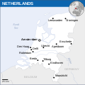
English: Locator map of Netherlands.
תאריך יצירה
מקור
יוצר
SVGהתפתחות 
InfoField
 
.קוד המקור של קובץ SVG זה הוא תקין
 
. Inkscape עם‎‎ נוצרה ה גרפיקה וקטורית
 
 This map uses embedded text that can be easily translated using a text editor.

רישיון

w:he:Creative Commons
ייחוס
הקובץ הזה מתפרסם לפי תנאי רישיון קריאייטיב קומונז ייחוס 3.0 לא מותאם.
ייחוס: OCHA
יש לך חופש:
  • לשתף – להעתיק, להפיץ ולהעביר את העבודה
  • לערבב בין עבודות – להתאים את העבודה
תחת התנאים הבאים:
  • ייחוס – יש לתת ייחוס הולם, לתת קישור לרישיון, ולציין אם נעשו שינויים. אפשר לעשות את זה בכל צורה סבירה, אבל לא בשום צורה שמשתמע ממנה שמעניק הרישיון תומך בך או בשימוש שלך.
This map is part of a collection of 216 free country maps, created by the UN Office for the Coordination of Humanitarian Affairs (OCHA), to be used in print, web or broadcast products.

The ReliefWeb Location Maps released here are maps that highlight a country, its capital, major populated places and the surrounding regions.

Attribution Requirements

Using the map without modifications: ensure that the sources and the disclaimer are below the map. Credit as follows: "Credit: OCHA".

For use with alteration: remove the OCHA logo and disclaimer following any modification to the map, but keep the data sources as mentioned below the map. Credit the modified map as follows: "Based on OCHA map". You are responsible for the content of your map.

We are keen to receive your feedback and hear how you used OCHA's maps. We would be grateful if you would notify us by e-mail and share your work with us.

UN Disclaimer
The designations employed and the presentation of material of this map do not imply the expression of any opinion whatsoever on the part of the Secretariat of the United Nations concerning the legal status of any country, territory, city or area or of its authorities or concerning the delimitation of its frontiers or boundaries.


Textual information (e.g. timestamp) once visible in the image itself has been moved into the image metadata and/or image description page. This makes the image easier to reuse and more language-neutral, and makes the text easier to process and search for. Commons discourages placing visible textual information in images. All licenses accepted on Commons permit this type of modification as a derivative work. If attribution information were removed and the image is not public domain, replace this tag with {{Attribution metadata from licensed image}}.

беларуская (тарашкевіца)‎ | català | Deutsch | English | español | فارسی | français | galego | magyar | italiano | македонски | മലയാളം | português | русский | sicilianu | slovenščina | svenska | Indonesia | 中文 | +/−

כיתובים

נא להוסיף משפט שמסביר מה הקובץ מייצג

פריטים שמוצגים בקובץ הזה

מוצג

image/svg+xml

היסטוריית הקובץ

ניתן ללחוץ על תאריך/שעה כדי לראות את הקובץ כפי שנראה באותו זמן.

תאריך/שעהתמונה ממוזערתממדיםמשתמשהערה
נוכחית19:28, 24 בדצמבר 2022תמונה ממוזערת לגרסה מ־19:28, 24 בדצמבר 2022‪251 × 250‬ (905 ק"ב)WikijahnnFile uploaded using svgtranslate tool (https://svgtranslate.toolforge.org/). Added translation for ca.
18:09, 24 במאי 2022תמונה ממוזערת לגרסה מ־18:09, 24 במאי 2022‪251 × 250‬ (904 ק"ב)NyilvosktFile uploaded using svgtranslate tool (https://svgtranslate.toolforge.org/). Added translation for id.
08:34, 2 בספטמבר 2016תמונה ממוזערת לגרסה מ־08:34, 2 בספטמבר 2016‪251 × 250‬ (902 ק"ב)Wereldburger758Resized page to drawing. Removal watermark. Validation of image.
12:36, 31 במרץ 2016תמונה ממוזערת לגרסה מ־12:36, 31 במרץ 2016‪254 × 254‬ (885 ק"ב)Wereldburger758Resized page to drawing. Removal watermark. Validation of image.
03:40, 8 במאי 2014תמונה ממוזערת לגרסה מ־03:40, 8 במאי 2014‪254 × 254‬ (883 ק"ב)UN OCHA maps bot== {{int:filedesc}} == {{Information |description={{en|1=Locator map of Netherlands.}} |date=2013 |source={{en|1=[http://reliefweb.int/map/netherlands/netherlands-location-map-2013 Netherlands Locator Map (ReliefWeb)]}} |author={{e...

אין דפים המשתמשים בקובץ זה.

שימוש גלובלי בקובץ

אתרי הוויקי האחרים הבאים משתמשים בקובץ הזה:

מטא־נתונים