
 Français
 Italiano
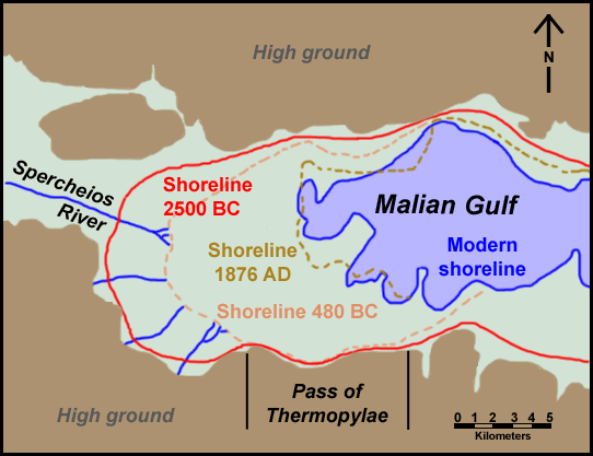
אין גרסה ברזולוציה גבוהה יותר.
Thermopylae_shoreline_changes_map.png (542 × 417 פיקסלים, גודל הקובץ: 88 ק"ב, סוג MIME: image/png)
זהו קובץ שמקורו במיזם ויקישיתוף. תיאורו בדף תיאור הקובץ המקורי (בעברית) מוצג למטה ויקישיתוף הוא מאגר תמונות וקובצי מדיה חופשיים. אתם יכולים לעזור. |
תקציר
| תיאור | English: Map of Thermopylae area with modern shoreline and reconstructed shorelines of 1872 AD, 480 BC and 2500 BC. Loosely based on figure 3.19 in Geoarchaeology: The Earth-science Approach to Archaeological Interpretation, p. 96. George Robert Rapp, Christopher L. Hill. Yale University Press, 2006. ISBN 0300109660 |
| תאריך יצירה | |
| מקור | נוצר על־ידי מעלה היצירה |
| יוצר | ChrisO |
| אישורים והיתרים (שימוש חוזר בקובץ זה) | Public domain |
רישיון
| ברצוני, בעלי זכויות היוצרים על יצירה זו, לשחרר יצירה זו לנחלת הכלל. זה תקף בכל העולם. יש מדינות שבהן הדבר אינו אפשרי על פי חוק, אם כך: אני מעניק לכל אחד את הזכות להשתמש בעבודה זו לכל מטרה שהיא, ללא תנאים כלשהם, אלא אם כן תנאים כאלה נדרשים על פי חוק. |
היסטוריית הקובץ
ניתן ללחוץ על תאריך/שעה כדי לראות את הקובץ כפי שנראה באותו זמן.
| תאריך/שעה | תמונה ממוזערת | ממדים | משתמש | הערה | |
|---|---|---|---|---|---|
| נוכחית | 11:27, 12 ביוני 2011 | | 417 × 542 (88 ק"ב) | Cplakidas | minor corrections on names |
| 03:00, 1 באוקטובר 2008 |  | 417 × 542 (31 ק"ב) | ChrisO | {{Information |Description={{en|1=Map of Thermopylae area with modern shoreline and reconstructed shorelines of 1872 AD, 480 BC and 2500 BC. Loosely based on figure 3.19 in ''Geoarchaeology: The Earth-science Approach to Archaeological Interpretation'', p |
שימוש בקובץ
אין דפים המשתמשים בקובץ זה.
שימוש גלובלי בקובץ
אתרי הוויקי האחרים הבאים משתמשים בקובץ הזה:
- שימוש באתר ar.wikipedia.org
- שימוש באתר azb.wikipedia.org
- שימוש באתר br.wikipedia.org
- שימוש באתר ca.wikipedia.org
- שימוש באתר da.wikipedia.org
- שימוש באתר de.wikipedia.org
- שימוש באתר el.wikipedia.org
- שימוש באתר en.wikipedia.org
- שימוש באתר fi.wikipedia.org
- שימוש באתר fr.wikipedia.org
- שימוש באתר hr.wikipedia.org
- שימוש באתר hu.wikipedia.org
- שימוש באתר id.wikipedia.org
- שימוש באתר la.wikipedia.org
- שימוש באתר mk.wikipedia.org
- שימוש באתר ru.wikipedia.org
- שימוש באתר sh.wikipedia.org
- שימוש באתר simple.wikipedia.org
- שימוש באתר sl.wikipedia.org
- שימוש באתר sr.wikipedia.org
- שימוש באתר tr.wikipedia.org
- שימוש באתר uk.wikipedia.org
- שימוש באתר vi.wikipedia.org
- שימוש באתר zh.wikipedia.org
Explore the world

United states
New York

Japan
Tokyo

Singapore
Singapore
