
 Français
 Italiano
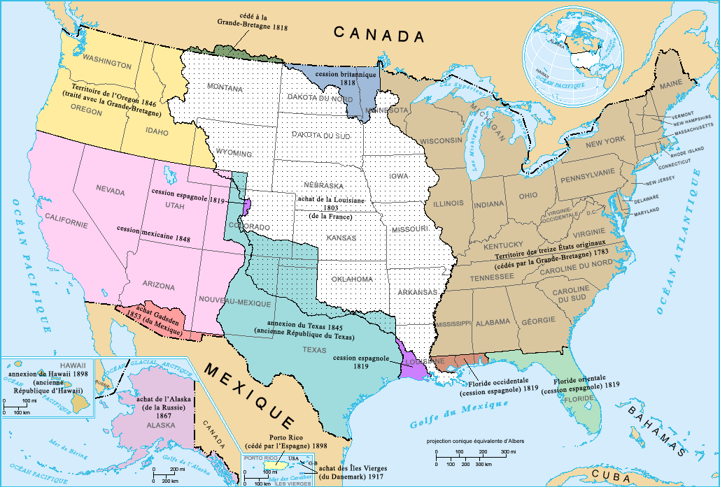
גודל התצוגה המקדימה הזאת: 800 × 542 פיקסלים. רזולוציות אחרות: 320 × 217 פיקסלים | 640 × 434 פיקסלים | 1,029 × 697 פיקסלים.
לקובץ המקורי (1,029 × 697 פיקסלים, גודל הקובץ: 183 ק"ב, סוג MIME: image/png)
זהו קובץ שמקורו במיזם ויקישיתוף. תיאורו בדף תיאור הקובץ המקורי (בעברית) מוצג למטה ויקישיתוף הוא מאגר תמונות וקובצי מדיה חופשיים. אתם יכולים לעזור. |
תקציר
French-version map of the territorial acquisitions of the United States.
For the English version, see : Image:USA_territorial_acquisitions.png.
- Sujet : Carte des acquisitions territoriales des États-Unis d'Amérique
- Réalisée par : US Department of Interior
- Source : National Atlas of the United States : http://nationalatlas.gov
- Traduction : par fr:Utilisateur:Sting
רישיון
This map was obtained from an edition of the National Atlas of the United States. Like almost all works of the U.S. federal government, works from the National Atlas are in the public domain in the United States. Online access: NationalAtlas.gov | 1970 print edition: Library of Congress, Perry-Castañeda Library
|
היסטוריית הקובץ
ניתן ללחוץ על תאריך/שעה כדי לראות את הקובץ כפי שנראה באותו זמן.
| תאריך/שעה | תמונה ממוזערת | ממדים | משתמש | הערה | |
|---|---|---|---|---|---|
| נוכחית | 20:15, 3 בפברואר 2006 | | 697 × 1,029 (183 ק"ב) | Sting | French-version map of the territorial acquisitions of the United States. For the English version, see : Image:USA_territorial_acquisitions.png. * '''Sujet :''' Carte des acquisitions territoriales des États-Unis d'Amérique * '''Réalisée pa |
שימוש בקובץ
אין דפים המשתמשים בקובץ זה.
שימוש גלובלי בקובץ
אתרי הוויקי האחרים הבאים משתמשים בקובץ הזה:
- שימוש באתר fr.wikipedia.org
- שימוש באתר la.wikipedia.org
מטא־נתונים
Explore the world

United states
New York

Japan
Tokyo

Singapore
Singapore
