
 Français
 Italiano
גודל התצוגה המקדימה הזאת: 592 × 599 פיקסלים. רזולוציות אחרות: 237 × 240 פיקסלים | 474 × 480 פיקסלים | 759 × 768 פיקסלים | 1,012 × 1,024 פיקסלים | 2,116 × 2,142 פיקסלים.
לקובץ המקורי (2,116 × 2,142 פיקסלים, גודל הקובץ: 388 ק"ב, סוג MIME: image/png)
זהו קובץ שמקורו במיזם ויקישיתוף. תיאורו בדף תיאור הקובץ המקורי (בעברית) מוצג למטה ויקישיתוף הוא מאגר תמונות וקובצי מדיה חופשיים. אתם יכולים לעזור. |
תקציר
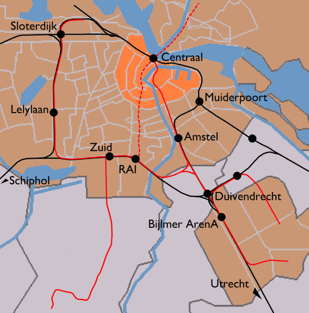
| תיאור | English: Map of Amsterdam's train stations. Greyish orange background denotes the municipality of Amsterdam, bright orange is the Amsterdam-Centrum district. Black lines are railways and red lines are metro lines. Dashed red line is a metro line under construction (to be opened 2013). Black dots are the train stations.
|
| תאריך יצירה | |
| מקור | Image modified by me, taken from Wikipedia Commons (Image:Outline map Amsterdam metro 2.PNG), which uses data from (and copyrighted by) the Dutch Centraal Bureau voor de Statistiek, which "allows anyone to use it for any purpose, provided that the copyright holder is properly attributed. Redistribution, derivative work, commercial use, and all other use is permitted." The map on Wikipedia was made by user Michiel1972, who placed his contribution in the public domain. I am doing the same for my modifications. |
| יוצר | CBS, Michiel1972, me ((WT-shared) Mtcv) |
| אישורים והיתרים (שימוש חוזר בקובץ זה) | attribution required; PD This image is (in part or entirely) based on geographical data from Statistics Netherlands (Centraal Bureau voor de Statistiek). Digital geometry files in ESRI format can be downloaded from their website [1]. In particular, boundary data of statistical districts is based on either the Wijk- en buurtkaart 2005, or the Wijk- en buurtkaart 2003 ("CBS/TOPgrenzen"). Data on localities (bevolkingskernen) are from the publication Bevolkingskernen in Nederland 2001. Conditions of use (in Dutch):
|
רישיון
| היצירה הזאת שוחררה לנחלת הכלל על־ידי היוצר שלה, User: (WT-shared) Mtcv at wts ויקימסע. זה תקף בכל העולם. יש מדינות שבהן הדבר אינו אפשרי על פי חוק, אם כך: User: (WT-shared) Mtcv at wts ויקימסע מעניק לכל אחד את הזכות להשתמש ביצירה הזאת לכל מטרה, ללא שום תנאי, אלא אם כן תנאים כאלה נדרשים לפי החוק.
|
יומן העלאה מקורי
| This file was imported from Wikivoyage WTS. |
תיאור הקובץ המקורי נמצא כאן. כל שמות המשתמשים הבאים מתייחסים ל-wts.wikivoyage-old.
- 2007-12-03 14:03 (WT-shared) Mtcv[dead link] 2116×2142 (397547 bytes) {{Information |description=Map of Amsterdam's train stations. |source=Image modified by me, taken from Wikipedia Commons ([http://commons.wi (Import from wikitravel.org/shared)
היסטוריית הקובץ
ניתן ללחוץ על תאריך/שעה כדי לראות את הקובץ כפי שנראה באותו זמן.
| תאריך/שעה | תמונה ממוזערת | ממדים | משתמש | הערה | |
|---|---|---|---|---|---|
| נוכחית | 23:08, 17 בנובמבר 2012 | | 2,142 × 2,116 (388 ק"ב) | MGA73bot2 | {{BotMoveToCommons|wts.oldwikivoyage|year={{subst:CURRENTYEAR}}|month={{subst:CURRENTMONTHNAME}}|day={{subst:CURRENTDAY}}}} == {{int:filedesc}} == {{Information |description=Map of Amsterdam's train stations. Greyish orange background denotes the munic... |
שימוש בקובץ
הדף הבא משתמש בקובץ הזה:
שימוש גלובלי בקובץ
אתרי הוויקי האחרים הבאים משתמשים בקובץ הזה:
מטא־נתונים
Explore the world

United states
New York

Japan
Tokyo

Singapore
Singapore
