
 Français
 Italiano
גודל התצוגה המקדימה הזאת מסוג PNG של קובץ ה־SVG הזה: 613 × 599 פיקסלים. רזולוציות אחרות: 246 × 240 פיקסלים | 491 × 480 פיקסלים | 786 × 768 פיקסלים | 1,048 × 1,024 פיקסלים | 2,095 × 2,048 פיקסלים | 1,023 × 1,000 פיקסלים.
לקובץ המקורי (קובץ SVG, הגודל המקורי: 1,023 × 1,000 פיקסלים, גודל הקובץ: 2.69 מ"ב)
זהו קובץ שמקורו במיזם ויקישיתוף. תיאורו בדף תיאור הקובץ המקורי (בעברית) מוצג למטה ויקישיתוף הוא מאגר תמונות וקובצי מדיה חופשיים. אתם יכולים לעזור. |
תקציר
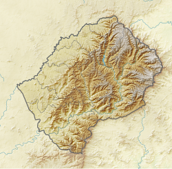
| תיאור | English: Relief location map of Lesotho Equirectangular projection. Geographic limits of the map:
|
| תאריך יצירה | |
| מקור | |
| יוצר |
|
| SVG |
רישיון
הקובץ הזה מתפרסם לפי תנאי רישיון קריאייטיב קומונז ייחוס-שיתוף זהה 3.0 לא מותאם.
- יש לך חופש:
- לשתף – להעתיק, להפיץ ולהעביר את העבודה
- לערבב בין עבודות – להתאים את העבודה
- תחת התנאים הבאים:
- ייחוס – יש לתת ייחוס הולם, לתת קישור לרישיון, ולציין אם נעשו שינויים. אפשר לעשות את זה בכל צורה סבירה, אבל לא בשום צורה שמשתמע ממנה שמעניק הרישיון תומך בך או בשימוש שלך.
- שיתוף זהה – יצירת רמיקס, שינוי או בנייה על סמך החומר הזה, תטיל עליך חובה להפיץ את התרומות שלך לפי תנאי רישיון זהה או תואם למקור.
היסטוריית הקובץ
ניתן ללחוץ על תאריך/שעה כדי לראות את הקובץ כפי שנראה באותו זמן.
| תאריך/שעה | תמונה ממוזערת | ממדים | משתמש | הערה | |
|---|---|---|---|---|---|
| נוכחית | 19:54, 22 באוקטובר 2013 | | 1,000 × 1,023 (2.69 מ"ב) | Htonl | update boundaries |
| 23:34, 4 בינואר 2013 |  | 1,000 × 1,023 (2.71 מ"ב) | Htonl | == {{int:filedesc}} == {{Information |Description ={{en|1=Relief location map of Lesotho Equirectangular projection. Geographic limits of the map: * N: 28.33° S * S: 30.89° S * W: 26.74° E * E: 29.62° E}} |Source =* ... |
שימוש בקובץ
הדף הבא משתמש בקובץ הזה:
שימוש גלובלי בקובץ
אתרי הוויקי האחרים הבאים משתמשים בקובץ הזה:
- שימוש באתר ar.wikipedia.org
- שימוש באתר bg.wikipedia.org
- שימוש באתר bs.wikipedia.org
- שימוש באתר ce.wikipedia.org
- שימוש באתר cs.wikipedia.org
- שימוש באתר el.wikipedia.org
- שימוש באתר eo.wikipedia.org
- שימוש באתר fi.wikipedia.org
- שימוש באתר ja.wikipedia.org
- שימוש באתר kaa.wikipedia.org
- שימוש באתר kn.wikipedia.org
- שימוש באתר ko.wikipedia.org
- שימוש באתר mk.wikipedia.org
- שימוש באתר nl.wikipedia.org
- שימוש באתר pl.wikipedia.org
- שימוש באתר sco.wikipedia.org
- שימוש באתר sq.wikipedia.org
- שימוש באתר st.wikipedia.org
- שימוש באתר sv.wikipedia.org
- Mafeteng
- Mall:Kartposition Lesotho
- Cairntoul
- Thaba-Tseka (distrikt)
- Användare:Lsjbot/Dubletter/Teyateyaneng
- Roma, Lesotho
- Användare:Lsjbot/Dubletter/Quthing
- Quthing (distrikt)
- Qoqolosing
- Qacha's Nek
- Qacha's Nek (distrikt)
- Thabana Ntlenyana
- Moteng Pass
- Användare:Lsjbot/Dubletter/Mokhotlong
- Mohale's Hoek
- Mohale's Hoek District
- Maseru (distrikt)
צפייה בשימושים גלובליים נוספים של הקובץ הזה.
מטא־נתונים
Explore the world

United states
New York

Japan
Tokyo

Singapore
Singapore
