
 Français
 Italiano
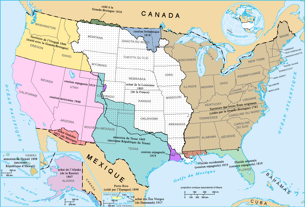
इस पूर्वावलोकन का आकार: ८०० × ५४२ पिक्सेल। दूसरे रेसोल्यूशन्स: ३२० × २१७ पिक्सेल | ६४० × ४३४ पिक्सेल | १,०२९ × ६९७ पिक्सेल।
मूल चित्र (१,०२९ × ६९७ चित्रतत्व, संचिका का आकार: १८३ KB, माइम प्रकार: image/png)
सारांश
French-version map of the territorial acquisitions of the United States.
For the English version, see : Image:USA_territorial_acquisitions.png.
- Sujet : Carte des acquisitions territoriales des États-Unis d'Amérique
- Réalisée par : US Department of Interior
- Source : National Atlas of the United States : http://nationalatlas.gov
- Traduction : par fr:Utilisateur:Sting
लाइसेंस
This map was obtained from an edition of the National Atlas of the United States. Like almost all works of the U.S. federal government, works from the National Atlas are in the public domain in the United States. Online access: NationalAtlas.gov | 1970 print edition: Library of Congress, Perry-Castañeda Library
|
चित्र का इतिहास
चित्र पुराने समय में कैसी दिखती थी यह जानने के लिए दिनांक/समय पर क्लिक करें।
| दिनांक/समय | थंबनेल | आकार | सदस्य | टिप्पणी | |
|---|---|---|---|---|---|
| वर्तमान | २२:४५, ३ फ़रवरी २००६ | | १,०२९ × ६९७ (१८३ KB) | Sting | French-version map of the territorial acquisitions of the United States. For the English version, see : Image:USA_territorial_acquisitions.png. * '''Sujet :''' Carte des acquisitions territoriales des États-Unis d'Amérique * '''Réalisée pa |
चित्र का उपयोग
कोई भी ऐसा पृष्ठ नहीं है जो इस चित्र का प्रयोग कर रहा हो।
चित्र का वैश्विक उपयोग
इस चित्र का उपयोग इन दूसरे विकियों में किया जाता है:
- fr.wikipedia.org पर उपयोग
- la.wikipedia.org पर उपयोग
मेटाडेटा
Explore the world

United states
New York

Japan
Tokyo

Singapore
Singapore
