
 Français
 Italiano
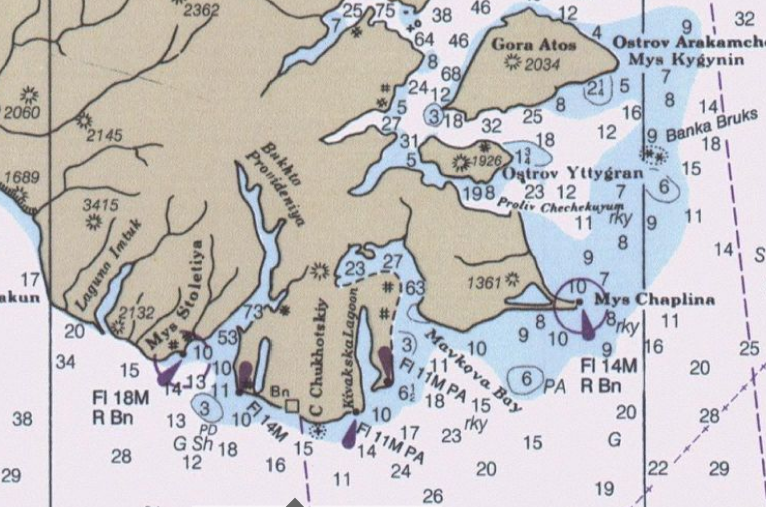
Geen hogere resolutie beschikbaar.
Cape_Chukotsky_region.PNG (766 × 507 pixels, bestandsgrootte: 788 kB, MIME-type: image/png)
Dit is een bestand van Wikimedia Commons. Onderstaande beschrijving komt van de beschrijving van het bestand daar. Commons is een vrij-gelicenceerde database voor afbeeldingen, geluid, video en andere bestanden. |
Beschrijving
| Beschrijving | English: detail from Bering Sea nautical Chart |
| Datum | |
| Bron | Historical Maps and Charts Project http://historicalcharts.noaa.gov/tiled_jpgs_done/zoomifyURLDrivenWebPage.htm?zoomifyImagePath=16006-12-2000 |
| Auteur | US Office of Coadt Survey, NOAA |
Licentie
Deze afbeelding is in het publiek domein omdat het materiaal bevat dat oorspronkelijk van de National Oceanic and Atmospheric Administration kwam in de Verenigde Staten en genomen of gemaakt is tijdens de officiële werkzaamheden van een werknemer.
|
Bestandsgeschiedenis
Klik op een datum/tijd om het bestand te zien zoals het destijds was.
| Datum/tijd | Miniatuur | Afmetingen | Gebruiker | Opmerking | |
|---|---|---|---|---|---|
| huidige versie | 8 okt 2009 20:52 | | 766 × 507 (788 kB) | Dankarl | {{Information |Description={{en|1=detail from Bering Sea nautical Chart}} |Source=Historical Maps and Charts Project http://historicalcharts.noaa.gov/tiled_jpgs_done/zoomifyURLDrivenWebPage.htm?zoomifyImagePath=16006-12-2000 |Author=US Office of Coadt Sur |
Bestandsgebruik
Geen enkele pagina gebruikt dit bestand.
Explore the world

United states
New York

Japan
Tokyo

Singapore
Singapore
