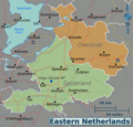
Grootte van deze voorvertoning: 626 × 600 pixels. Andere resoluties: 250 × 240 pixels | 501 × 480 pixels | 801 × 768 pixels | 1.069 × 1.024 pixels | 2.137 × 2.048 pixels | 2.997 × 2.872 pixels.
Oorspronkelijk bestand (2.997 × 2.872 pixels, bestandsgrootte: 1,61 MB, MIME-type: image/png)
Bestandsgeschiedenis
Klik op een datum/tijd om het bestand te zien zoals het destijds was.
| Datum/tijd | Miniatuur | Afmetingen | Gebruiker | Opmerking | |
|---|---|---|---|---|---|
| huidige versie | 22 jan 2013 03:54 |  | 2.997 × 2.872 (1,61 MB) | Globe-trotter | {{Information |Description ={{en|1=Map of the Eastern Netherlands.}} |Source ={{own}} based on [http://www.lib.utexas.edu/maps/netherlands.html University of Texas Library - Perry Castañeda Map Collection] (public domain); [[:File:ATB-kaart... |
Bestandsgebruik
Dit bestand wordt op de volgende 2 pagina's gebruikt:
Globaal bestandsgebruik
Dit bestand wordt op de volgende andere wiki’s gebruikt:
- Gebruikt op el.wikivoyage.org
- Gebruikt op en.wikivoyage.org
- Gebruikt op it.wikivoyage.org


 Français
 Italiano


