
 Français
 Italiano
Grootte van deze voorvertoning: 800 × 578 pixels. Andere resoluties: 320 × 231 pixels | 640 × 462 pixels | 1.022 × 738 pixels.
Oorspronkelijk bestand (1.022 × 738 pixels, bestandsgrootte: 88 kB, MIME-type: image/png)
Dit is een bestand van Wikimedia Commons. Onderstaande beschrijving komt van de beschrijving van het bestand daar. Commons is een vrij-gelicenceerde database voor afbeeldingen, geluid, video en andere bestanden. |
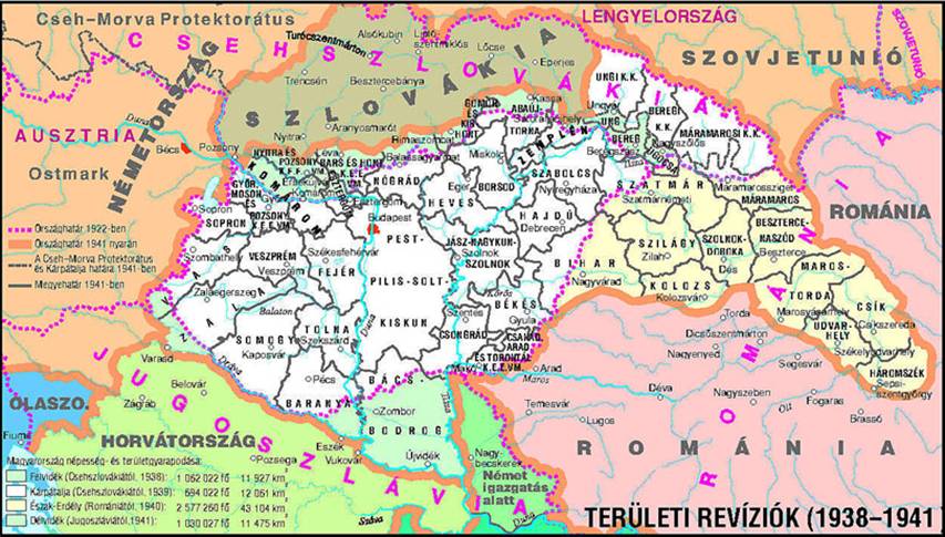
| Beschrijving | English: Map of territories annexed by Hungary in 1938-1941. | ||
| Datum | |||
| Bron | Eigen werk - derivative work; modified version of this map whose author was User:PANONIAN: File:Hungary map.png. | ||
| Auteur | Mixx321 | ||
| Toestemming (Hergebruik van dit bestand) | Ik, de auteursrechthebbende van dit werk, maak het hierbij onder de volgende licentie beschikbaar:
|

References
- The Times History of Europe, Times Books, London, 2002
- Richard Overy, The Times History of the 20th Century, Times Books, London, 2004.
- Peter Rokai - Zoltan Đere - Tibor Pal - Aleksandar Kasaš, Istorija Mađara, Beograd, 2002.
- http://terkepek.adatbank.transindex.ro/kepek/netre/224.gif archief kopie op de Wayback Machine
- http://www.hunmagyar.org/tor/terkep.jpg
- http://www.map.hu/galeria/orig/1426_hu_in_maps_fig_12_states_1648-2009.jpg archief kopie op de Wayback Machine
- http://magyar.files.wordpress.com/2006/07/11399032041.JPG?w=440&h=343
- http://crowland.uw.hu/images/csata/delvidek_02.jpg archief kopie op de Wayback Machine
- http://www.conflicts.rem33.com/images/Ungarn/hunhist_V_files/image004.jpg
Other versions
Bestandsgeschiedenis
Klik op een datum/tijd om het bestand te zien zoals het destijds was.
| Datum/tijd | Miniatuur | Afmetingen | Gebruiker | Opmerking | |
|---|---|---|---|---|---|
| huidige versie | 14 apr 2014 21:35 | | 1.022 × 738 (88 kB) | WikiEditor2004 | more regional names + I will elaborate poland and ukraine issues on talk page |
| 26 feb 2014 22:23 |  | 1.022 × 738 (80 kB) | Poeticbent | more legend, added missing historical names and dates | |
| 17 feb 2014 19:38 |  | 1.022 × 738 (74 kB) | WikiEditor2004 | corrected borders and improved aesthetics | |
| 1 sep 2010 17:52 |  | 1.023 × 738 (60 kB) | Mixx321 | {{Information |Description={{en|1=Map of territories added to Hungary 1938-1947}} |Source={{own}} |Author=Mixx321 |Date=2010.IX.1 |Permission={{GFDL-self}} |other_versions= }} File:Hungary_map.png [[Category:History of Hungary betwee |
Bestandsgebruik
Geen enkele pagina gebruikt dit bestand.
Globaal bestandsgebruik
Dit bestand wordt op de volgende andere wiki’s gebruikt:
- Gebruikt op be.wikipedia.org
- Gebruikt op bs.wikipedia.org
- Gebruikt op en.wikipedia.org
- Gebruikt op es.wikipedia.org
- Gebruikt op et.wikipedia.org
- Gebruikt op fi.wikipedia.org
- Gebruikt op fr.wikipedia.org
- Gebruikt op he.wikipedia.org
- Gebruikt op id.wikipedia.org
- Gebruikt op no.wikipedia.org
- Gebruikt op pl.wikipedia.org
- Gebruikt op pt.wikipedia.org
- Gebruikt op sr.wikipedia.org
- Gebruikt op th.wikipedia.org
- Gebruikt op uk.wikipedia.org
Explore the world

United states
New York

Japan
Tokyo

Singapore
Singapore
