
 Français
 Italiano
Afmetingen van deze voorvertoning van het type PNG van dit SVG-bestand: 497 × 599 pixels Andere resoluties: 199 × 240 pixels | 398 × 480 pixels | 637 × 768 pixels | 850 × 1.024 pixels | 1.699 × 2.048 pixels | 1.116 × 1.345 pixels.
Oorspronkelijk bestand (SVG-bestand, nominaal 1.116 × 1.345 pixels, bestandsgrootte: 1,6 MB)
Dit is een bestand van Wikimedia Commons. Onderstaande beschrijving komt van de beschrijving van het bestand daar. Commons is een vrij-gelicenceerde database voor afbeeldingen, geluid, video en andere bestanden. |
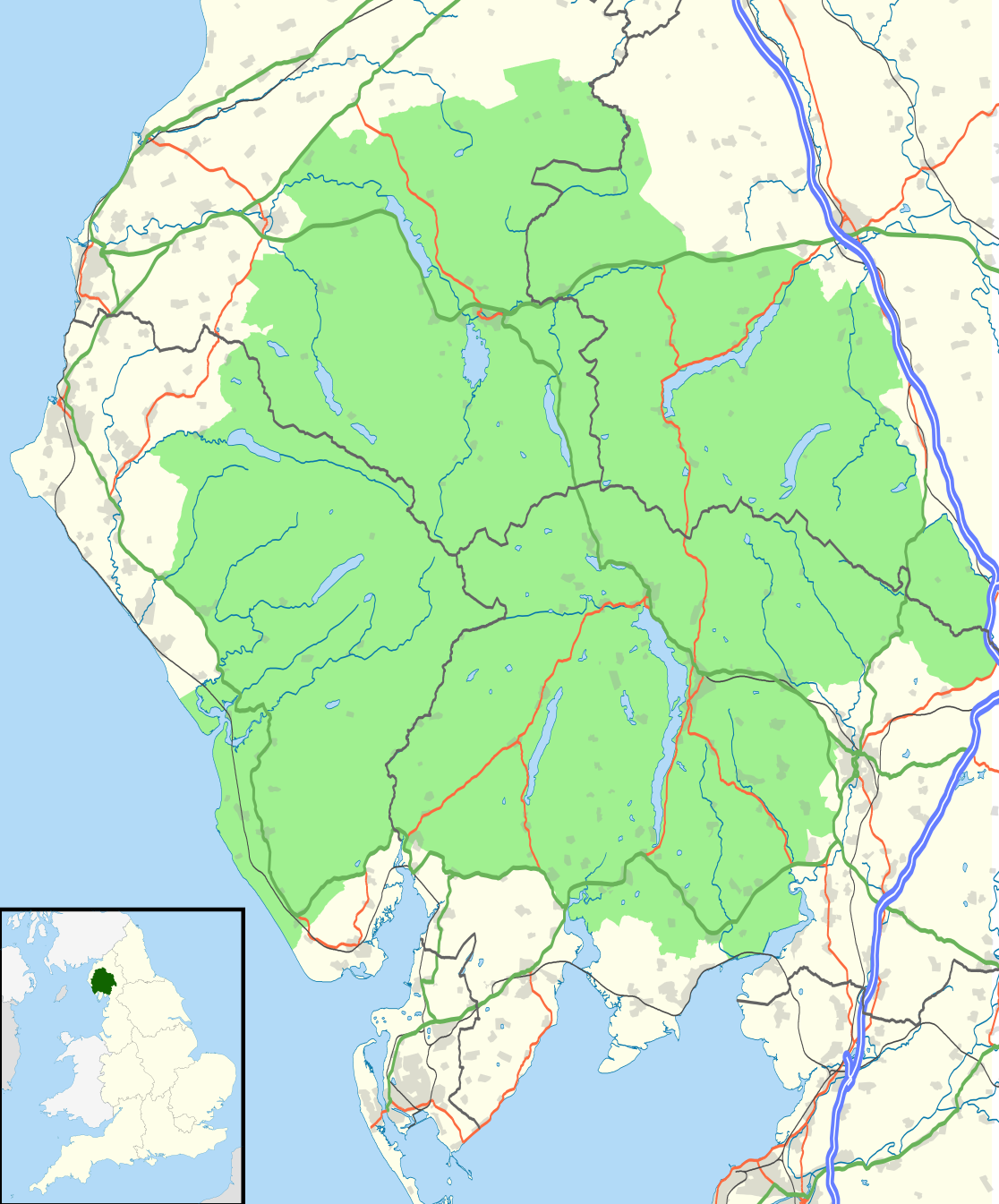
| Beschrijving | Map of the Lake District National Park, UK with the following information shown:
Equirectangular map projection on WGS 84 datum, with N/S stretched 170% Geographic limits:
|
| Datum | |
| Bron | Office of National Statistics Geography
|
| Auteur | Nilfanion, created using Ordnance Survey data |
| Toestemming (Hergebruik van dit bestand) | Dit bestand is gelicenseerd onder de Creative Commons-licentie Naamsvermelding-Gelijk delen 3.0 Unported Naamsvermelding: Contains Ordnance Survey data © Crown copyright and database right
|
Bestandsgeschiedenis
Klik op een datum/tijd om het bestand te zien zoals het destijds was.
| Datum/tijd | Miniatuur | Afmetingen | Gebruiker | Opmerking | |
|---|---|---|---|---|---|
| huidige versie | 4 aug 2016 23:05 | | 1.116 × 1.345 (1,6 MB) | Rcsprinter123 | Amendments per the Lake District National Park (Designation) (Variation) Order 2012. |
| 29 okt 2010 23:32 |  | 1.108 × 1.345 (1,48 MB) | Nilfanion | {{Information |Description=Map of the Lake District National Park, UK with the following information shown: *National Park boundary *Administrative borders *Coastline, lakes and rivers *Roads and railways *Urban areas Equirectangular |
Bestandsgebruik
Dit bestand wordt op de volgende pagina gebruikt:
Globaal bestandsgebruik
Dit bestand wordt op de volgende andere wiki’s gebruikt:
- Gebruikt op ar.wikipedia.org
- Gebruikt op ban.wikipedia.org
- Gebruikt op br.wikipedia.org
- Gebruikt op ceb.wikipedia.org
- Gebruikt op de.wikipedia.org
- Gebruikt op en.wikipedia.org
- Gebruikt op es.wikipedia.org
- Gebruikt op fa.wikipedia.org
- Gebruikt op fy.wikipedia.org
- Gebruikt op he.wikipedia.org
- Gebruikt op hi.wikipedia.org
- Gebruikt op hy.wikipedia.org
- Gebruikt op ja.wikipedia.org
- Gebruikt op kn.wikipedia.org
- Gebruikt op ml.wikipedia.org
- Gebruikt op nl.wikipedia.org
- Gebruikt op nn.wikipedia.org
- Gebruikt op pl.wikipedia.org
- Gebruikt op ro.wikipedia.org
- Gebruikt op ru.wikipedia.org
- Gebruikt op simple.wikipedia.org
- Gebruikt op si.wikipedia.org
- Gebruikt op sl.wikipedia.org
- Gebruikt op ta.wikipedia.org
- Gebruikt op th.wikipedia.org
- Gebruikt op tr.wikipedia.org
- Gebruikt op uk.wikipedia.org
- Gebruikt op war.wikipedia.org
Metadata
Explore the world

United states
New York

Japan
Tokyo

Singapore
Singapore
