
 Français
 Italiano
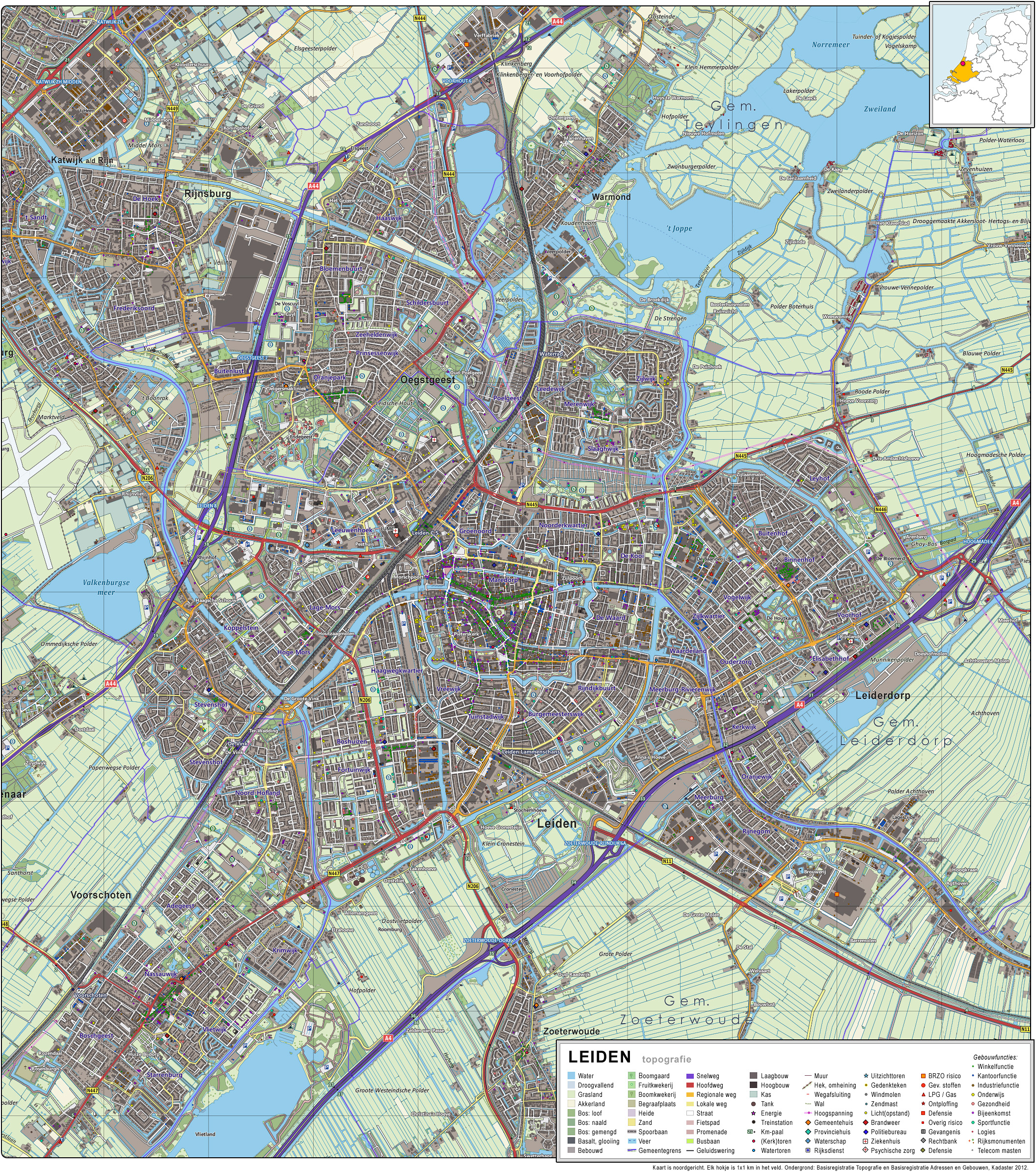
Grootte van deze voorvertoning: 530 × 599 pixels. Andere resoluties: 212 × 240 pixels | 424 × 480 pixels | 679 × 768 pixels | 905 × 1.024 pixels | 2.110 × 2.386 pixels.
Oorspronkelijk bestand (2.110 × 2.386 pixels, bestandsgrootte: 4,26 MB, MIME-type: image/jpeg)
Dit is een bestand van Wikimedia Commons. Onderstaande beschrijving komt van de beschrijving van het bestand daar. Commons is een vrij-gelicenceerde database voor afbeeldingen, geluid, video en andere bestanden. |
Beschrijving
| Beschrijving | Nederlands: Topografisch beeld van de stad Leiden. Op basis van de GML open geodata van de BRT/Top10NL (basisregistratie Topografie, Kadaster 2012), vrijgegeven door Kadaster op 30-11-2012 onder de Creative Commons BY licentie. Gebouwvlakken vanuit Open Geodata BAG extract (december 2012). Samenstelling en kleurenschema: Jan-Willem van Aalst, met QuantumGIS en Photoshop. |
| Datum | |
| Bron | Eigen werk |
| Auteur | Janwillemvanaalst |
Licentie
Ik, de auteursrechthebbende van dit werk, maak het hierbij onder de volgende licentie beschikbaar:
Dit bestand is gelicenseerd onder de Creative Commons-licentie Naamsvermelding-Gelijk delen 3.0 Unported
- De gebruiker mag:
- Delen – het werk kopiëren, verspreiden en doorgeven
- Remixen – afgeleide werken maken
- Onder de volgende voorwaarden:
- naamsvermelding – U moet op een gepaste manier aan naamsvermelding doen, een link naar de licentie geven, en aangeven of er wijzigingen in het werk zijn aangebracht. U mag dit op elke redelijke manier doen, maar niet zodanig dat de indruk wordt gewekt dat de licentiegever instemt met uw werk of uw gebruik van zijn werk.
- Gelijk delen – Als u het materiaal remixt, transformeert of erop voortbouwt, moet u uw bijdragen verspreiden onder dezelfde licentie als die van het origineel, of een licentie die daarmee verenigbaar is.
Bestandsgeschiedenis
Klik op een datum/tijd om het bestand te zien zoals het destijds was.
| Datum/tijd | Miniatuur | Afmetingen | Gebruiker | Opmerking | |
|---|---|---|---|---|---|
| huidige versie | 12 jan 2013 15:21 | | 2.110 × 2.386 (4,26 MB) | Janwillemvanaalst | Added various topographic improvements, which were already available in the BRT open-geodata source files: - Symbols for special physical appearances of land types such as "swampy terrain" - Symbol for carpool parking + large open parking spaces (in ad... |
| 5 jan 2013 14:54 |  | 2.110 × 2.386 (4,1 MB) | Janwillemvanaalst | Various rendering improvements, following the advice of several topographic experts. Scale remains unchanged. | |
| 30 dec 2012 15:05 |  | 2.110 × 2.386 (4,01 MB) | Janwillemvanaalst | Map redrawn using updated (Dec. 2012) open geodata Dutch government base registries BRT + BAG. Rendered using QuantumGIS and Photoshop. | |
| 16 mrt 2012 17:30 |  | 3.478 × 3.524 (5,16 MB) | Janwillemvanaalst | Building polygons now taken from Open Geodata BAG registry (Jan. 2012); increased image resolution. | |
| 15 feb 2012 18:53 |  | 2.400 × 2.379 (3,52 MB) | Janwillemvanaalst |
Bestandsgebruik
Dit bestand wordt op de volgende pagina gebruikt:
Metadata
Explore the world

United states
New York

Japan
Tokyo

Singapore
Singapore
