
 Français
 Italiano
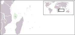
Geen hogere resolutie beschikbaar.
LocationComoros.png (250 × 119 pixels, bestandsgrootte: 5 kB, MIME-type: image/png)
Dit is een bestand van Wikimedia Commons. Onderstaande beschrijving komt van de beschrijving van het bestand daar. Commons is een vrij-gelicenceerde database voor afbeeldingen, geluid, video en andere bestanden. |
Locator map for the Comoros.
Originally created for English Wikipedia by Vardion.
| | Dit bestand is door Vardion op English Wikimedia Commons, in het publieke domein geplaatst. Dit is wereldwijd van toepassing. In sommige landen is dit niet mogelijk; in die gevallen geldt: |
 | Bestand:LocationComoros.svg is een vectorversie van dit bestand. Indien niet van slechtere kwaliteit dient deze gebruikt te worden in plaats van deze rasterafbeelding. File:LocationComoros.png → File:LocationComoros.svg Zie Help:SVG voor meer informatie. |  |
Bestandsgeschiedenis
Klik op een datum/tijd om het bestand te zien zoals het destijds was.
| Datum/tijd | Miniatuur | Afmetingen | Gebruiker | Opmerking | |
|---|---|---|---|---|---|
| huidige versie | 5 mrt 2008 16:22 | | 250 × 119 (5 kB) | Panos84 | Location of the island nation of Comoros and its exclusive economic zone. |
| 12 dec 2004 01:00 |  | 250 × 115 (6 kB) | EugeneZelenko | Location map for the Comoros.<br/>Originally created for English Wikipedia by Vardion.<br/>{{PD}}<br/>Category:Country locator maps |
Bestandsgebruik
Dit bestand wordt op de volgende pagina gebruikt:
Globaal bestandsgebruik
Dit bestand wordt op de volgende andere wiki’s gebruikt:
- Gebruikt op ar.wikipedia.org
- Gebruikt op bg.wikipedia.org
- Gebruikt op bn.wikivoyage.org
- Gebruikt op bpy.wikipedia.org
- Gebruikt op bs.wikipedia.org
- Gebruikt op ceb.wikipedia.org
- Gebruikt op de.wikinews.org
- Gebruikt op de.wiktionary.org
- Gebruikt op en.wikipedia.org
- Gebruikt op en.wikivoyage.org
- Gebruikt op en.wiktionary.org
- Gebruikt op eo.wikipedia.org
- Gebruikt op es.wikipedia.org
- Gebruikt op eu.wiktionary.org
- Gebruikt op frp.wikipedia.org
- Gebruikt op fr.wikipedia.org
- Gebruikt op fr.wiktionary.org
- Gebruikt op he.wikivoyage.org
- Gebruikt op hif.wikipedia.org
- Gebruikt op hr.wiktionary.org
- Gebruikt op hu.wikipedia.org
Globaal gebruik van dit bestand bekijken.
Explore the world

United states
New York

Japan
Tokyo

Singapore
Singapore
