
 Français
 Italiano
Oorspronkelijk bestand (4.438 × 3.524 pixels, bestandsgrootte: 15,04 MB, MIME-type: image/jpeg)
Dit is een bestand van Wikimedia Commons. Onderstaande beschrijving komt van de beschrijving van het bestand daar. Commons is een vrij-gelicenceerde database voor afbeeldingen, geluid, video en andere bestanden. |
Beschrijving
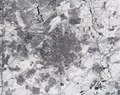
| Beschrijving | English: Captured by the Copernicus Sentinel-2 mission on 11 January 2021 at 12:14 CET, this image of Madrid in Spain appears to have been taken in black and white. In fact, it is a true-colour image – but the heaviest snowfall in 50 years has blanketed the region, turning the landscape white. Storm Filomena hit Spain over the weekend, blanketing parts of the country in thick snow and leaving half of the country on red alert. Madrid, one of the worst affected areas, was brought to a standstill with the airport having to be closed, trains cancelled and roads blocked. Although this satellite image was taken after the storm had passed, it is clear to see that much snow still remains, especially in the outskirts of the city. For example, some runways at the airport, which is visible in the top-right of the image, are still covered by snow. The unusual cold weather on the Iberian Peninsula is expected to last until later this week with temperatures forecasted to plunge to –12°C. The race is on to clear roads so that supplies of essential goods such as food supplies and Covid vaccines can be delivered. Copernicus Sentinel-2 is a two-satellite mission. Each satellite carries a high-resolution camera that images Earth’s surface in 13 spectral bands. Together they cover all Earth’s land surfaces, large islands, inland and coastal waters every five days at the equator. Credits: contains modified Copernicus Sentinel data (2021), processed by ESA, CC BY-SA 3.0 IGOالعربية: يبدو أن هذه الصورة لمدريد في إسبانيا تم التقاطها بواسطة مهمة Copernicus Sentinel-2 في 11 يناير 2021 الساعة 12:14 بتوقيت وسط أوروبا. في الواقع، إنها صورة ملونة حقيقية - ولكن تساقط الثلوج بكثافة منذ 50 عاما غطى المنطقة، مما حول المناظر الطبيعية إلى اللون الأبيض. ضربت العاصفة فيلومينا إسبانيا خلال عطلة نهاية الأسبوع، حيث غطت أجزاء من البلاد بالثلوج الكثيفة وتركت نصف البلاد في حالة تأهب أحمر. وتوقفت حركة مدريد، إحدى المناطق الأكثر تضررا، حيث اضطرت إلى إغلاق المطار وإلغاء القطارات وإغلاق الطرق. وعلى الرغم من أن هذه الصورة الفضائية تم التقاطها بعد مرور العاصفة، إلا أنه من الواضح أن الكثير من الثلوج لا تزال قائمة، خاصة في ضواحي المدينة. على سبيل المثال، لا تزال بعض مدارج الطائرات في المطار، والتي تظهر في أعلى يمين الصورة، مغطاة بالثلوج. من المتوقع أن يستمر الطقس البارد غير المعتاد في شبه الجزيرة الأيبيرية حتى وقت لاحق من هذا الأسبوع، حيث من المتوقع أن تنخفض درجات الحرارة إلى -12 درجة مئوية. السباق مستمر لتطهير الطرق حتى يمكن توصيل إمدادات السلع الأساسية مثل الإمدادات الغذائية ولقاحات كوفيد. كوبرنيكوس سنتينل-2 هي مهمة مكونة من قمرين صناعيين. ويحمل كل قمر صناعي كاميرا عالية الدقة تقوم بتصوير سطح الأرض في 13 نطاقًا طيفيًا. وهي تغطي معًا جميع أسطح الأرض والجزر الكبيرة والمياه الداخلية والساحلية كل خمسة أيام عند خط الاستواء. الاعتمادات: تحتوي على بيانات كوبرنيكوس سنتينل المعدلة (2021)، تمت معالجتها بواسطة وكالة الفضاء الأوروبية، CC BY-SA 3.0 IGO |
| Datum | |
| Bron | https://www.flickr.com/photos/europeanspaceagency/50827370368/ - Madrid snowbound |
| Auteur | European Space Agency |
| Andere versies |
|
| Activity | Observing the Earth |
| Mission | Sentinel-2 |
| System | Copernicus |
| Cameralocatie | | Deze en andere afbeeldingen in: OpenStreetMap |
|---|
|
Licentie
 | This image contains data from a satellite in the Copernicus Programme, such as Sentinel-1, Sentinel-2 or Sentinel-3. Attribution is required when using this image. Naamsvermelding: Contains modified Copernicus Sentinel data 2021 The use of Copernicus Sentinel Data is regulated under EU law (Commission Delegated Regulation (EU) No 1159/2013 and Regulation (EU) No 377/2014). Relevant excerpts:
Free access shall be given to GMES dedicated data [...] made available through GMES dissemination platforms [...].
Access to GMES dedicated data [...] shall be given for the purpose of the following use in so far as it is lawful:
GMES dedicated data [...] may be used worldwide without limitations in time.
GMES dedicated data and GMES service information are provided to users without any express or implied warranty, including as regards quality and suitability for any purpose. |
This media was created by the European Space Agency (ESA). Where expressly so stated, images or videos are covered by the Creative Commons Attribution-ShareAlike 3.0 IGO (CC BY-SA 3.0 IGO) licence, ESA being an Intergovernmental Organisation (IGO), as defined by the CC BY-SA 3.0 IGO licence. The user is allowed under the terms and conditions of the CC BY-SA 3.0 IGO license to Reproduce, Distribute and Publicly Perform the ESA images and videos released under CC BY-SA 3.0 IGO licence and the Adaptations thereof, without further explicit permission being necessary, for as long as the user complies with the conditions and restrictions set forth in the CC BY-SA 3.0 IGO licence, these including that:
See the ESA Creative Commons copyright notice for complete information, and this article for additional details. |  | |
Dit bestand is gelicenseerd onder de Creative Commons Naamsvermelding-GelijkDelen 3.0 IGO licentie. Naamsvermelding: ESA, CC BY-SA IGO 3.0
| ||
| Deze afbeelding is oorspronkelijk op Flickr geplaatst door europeanspaceagency op https://flickr.com/photos/37472264@N04/50827370368. Dit is op 12 januari 2021 door de FlickreviewR 2-Bot beoordeeld en de licentie onder de voorwaarden van cc-by-sa-2.0 is bevestigd. |
| Aantekeningen | Deze afbeelding is aangetekend: Bekijk de aantekeningen op Commons |
 | Deze afbeelding is beoordeeld op basis van de criteria voor waardevolle afbeeldingen en wordt beschouwd als de meest waardevolle afbeelding op Commons binnen het onderwerpgebied: Satellite picture of Storm Filomena, snowfall over the Community of Madrid.. Deze nominatie kan bekeken worden op Commons:Valued image candidates/Madrid snowbound.jpg. |
Bestandsgeschiedenis
Klik op een datum/tijd om het bestand te zien zoals het destijds was.
| Datum/tijd | Miniatuur | Afmetingen | Gebruiker | Opmerking | |
|---|---|---|---|---|---|
| huidige versie | 12 jan 2021 16:46 | | 4.438 × 3.524 (15,04 MB) | Up and Go | Uploaded a work by European Space Agency from https://www.flickr.com/photos/europeanspaceagency/50827370368/ with UploadWizard |
Bestandsgebruik
Geen enkele pagina gebruikt dit bestand.
Globaal bestandsgebruik
Dit bestand wordt op de volgende andere wiki’s gebruikt:
- Gebruikt op en.wikipedia.org
- Gebruikt op es.wikipedia.org
- Gebruikt op pt.wikipedia.org
Metadata
Explore the world

United states
New York

Japan
Tokyo

Singapore
Singapore
