
 Français
 Italiano
Afmetingen van deze voorvertoning van het type PNG van dit SVG-bestand: 800 × 480 pixels Andere resoluties: 320 × 192 pixels | 1.024 × 614 pixels | 1.280 × 768 pixels | 2.560 × 1.536 pixels.
Oorspronkelijk bestand (SVG-bestand, nominaal 800 × 480 pixels, bestandsgrootte: 86 kB)
Dit is een bestand van Wikimedia Commons. Onderstaande beschrijving komt van de beschrijving van het bestand daar. Commons is een vrij-gelicenceerde database voor afbeeldingen, geluid, video en andere bestanden. |
Beschrijving
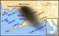
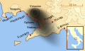
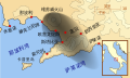
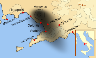
| Beschrijving | English: A map showing the cities and towns (with their Latin names which were affected by the eruption of Mount Vesuvius in 79 AD ; the general shape of the ash and cinder fall —see w:en:pyroclast— is shown by the dark area to the southeast of Mt Vesuvius. This map shows modern day coast lines and uses the Mercator projection (although that is not important on a map of this scale). North is, as usual, at the top of the map. Español: El mapa muestra las ciudades y los poblados (con sus nombres en latín) que fueron afectados por la erupción del Vesubio del año 79 d.C. ; las cenizas y los residuos de la erupción volcánica —consultar Piroclasto (tefra)— cayeron al sureste del Monte Vesubio, donde está indicado por la zona oscurecida. |
| Datum | |
| Bron | Eigen werk |
| Auteur | MapMaster |
References
This map is intended to show the general distribution of (airborne) ash punice, and other particles. I built the map from descriptions of the event as well as these maps:
- Luongo, Giuseppe; Perrotta, Annamaria; Scarpati, Claudio;De Carolis, Ernesto;Patricelli, Giovanni;Ciarallo, Annamaria (2003) "Impact of the AD 79 explosive eruption on Pompeii archief kopie op de Wayback Machine" in Journal of Volcanology and Geothermal Research v126 pp. 169-200.
- This map.
- Image:Pompeya, el Vesuvio y su alcance.jpg
Other versions
[]
-
 English
 -
 français
 -
 Latina
 -
 Nederlands
 -
 português
 -
 македонски
 -
 русский
 -
 中文
中文 -
 עברית
עברית


| Dit SVG-bestand maakt gebruik van geïntegreerde tekst die gemakkelijk kan worden vertaald naar uw taal met een SVG editor, een tekstverwerker of het hulpmiddel SVG Translate. Uitleg |
Licentie
Ik, de auteursrechthebbende van dit werk, maak het hierbij onder de volgende licenties beschikbaar:
 | Toestemming wordt verleend voor het kopiëren, verspreiden en/of wijzigen van dit document onder de voorwaarden van de GNU-licentie voor vrije documentatie, versie 1.2 of enige latere versie als gepubliceerd door de Free Software Foundation; zonder Invariant Sections, zonder Front-Cover Texts, en zonder Back-Cover Texts. Een kopie van de licentie is opgenomen in de sectie GNU-licentie voor vrije documentatie. |
Dit bestand is gelicenseerd onder de Creative Commons-licenties Naamsvermelding-Gelijk delen 3.0 Unported, 2.5 Algemeen, 2.0 Algemeen en 1.0 Algemeen.
- De gebruiker mag:
- Delen – het werk kopiëren, verspreiden en doorgeven
- Remixen – afgeleide werken maken
- Onder de volgende voorwaarden:
- naamsvermelding – U moet op een gepaste manier aan naamsvermelding doen, een link naar de licentie geven, en aangeven of er wijzigingen in het werk zijn aangebracht. U mag dit op elke redelijke manier doen, maar niet zodanig dat de indruk wordt gewekt dat de licentiegever instemt met uw werk of uw gebruik van zijn werk.
- Gelijk delen – Als u het materiaal remixt, transformeert of erop voortbouwt, moet u uw bijdragen verspreiden onder dezelfde licentie als die van het origineel, of een licentie die daarmee verenigbaar is.
U mag zelf één van de licenties kiezen.
Bestandsgeschiedenis
Klik op een datum/tijd om het bestand te zien zoals het destijds was.
| Datum/tijd | Miniatuur | Afmetingen | Gebruiker | Opmerking | |
|---|---|---|---|---|---|
| huidige versie | 6 apr 2018 10:00 | | 800 × 480 (86 kB) | -donald- | K changed to km |
| 29 nov 2014 00:04 |  | 800 × 480 (88 kB) | Ras67 | frame removed | |
| 19 okt 2007 02:17 |  | 659 × 396 (113 kB) | MapMaster | slight modification | |
| 16 okt 2007 00:35 |  | 659 × 396 (113 kB) | MapMaster | slight image fix-up | |
| 15 okt 2007 19:52 |  | 652 × 396 (113 kB) | MapMaster | == Summary == {{Information |Description=A map showing the cities and towns affected by the eruption of Mount Vesuvius in 79 AD. The general shape of the ash and cinder fall (see w:en:pyroclast) is shown by the dark area to the southeast of Mt Vesuvi |
Bestandsgebruik
Geen enkele pagina gebruikt dit bestand.
Globaal bestandsgebruik
Dit bestand wordt op de volgende andere wiki’s gebruikt:
- Gebruikt op af.wikipedia.org
- Gebruikt op bg.wikipedia.org
- Gebruikt op br.wikipedia.org
- Gebruikt op ca.wikipedia.org
- Gebruikt op da.wikipedia.org
- Gebruikt op de.wikipedia.org
- Gebruikt op de.wikivoyage.org
- Gebruikt op en.wikipedia.org
- Gebruikt op es.wikipedia.org
- Gebruikt op et.wikipedia.org
- Gebruikt op fi.wikipedia.org
- Gebruikt op fr.wikipedia.org
- Gebruikt op fur.wikipedia.org
- Gebruikt op fy.wikipedia.org
Globaal gebruik van dit bestand bekijken.
Metadata
Explore the world

United states
New York

Japan
Tokyo

Singapore
Singapore
