
 Français
 Italiano
Grootte van deze voorvertoning: 800 × 504 pixels. Andere resoluties: 320 × 202 pixels | 640 × 404 pixels | 1.024 × 646 pixels | 1.280 × 807 pixels | 2.184 × 1.377 pixels.
Oorspronkelijk bestand (2.184 × 1.377 pixels, bestandsgrootte: 1,46 MB, MIME-type: image/jpeg)
Dit is een bestand van Wikimedia Commons. Onderstaande beschrijving komt van de beschrijving van het bestand daar. Commons is een vrij-gelicenceerde database voor afbeeldingen, geluid, video en andere bestanden. |
|
Beschrijving
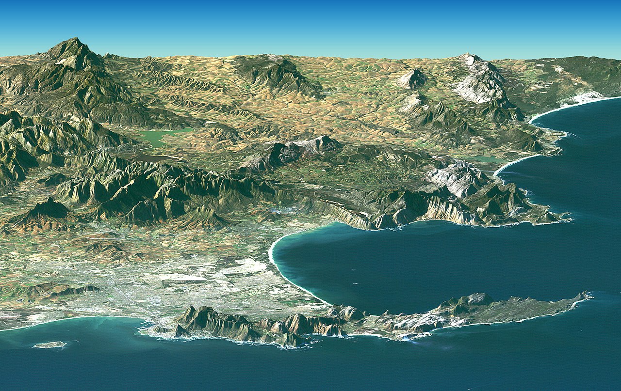
| Beschrijving | Afrikaans: 'n Satellietbeeld van die Kaapse Skiereiland en aanliggende Wes-Kaap in Suid-Afrika wat in Februarie 2000 deur Nasa met behulp van hul Landsat verkry is. Kaapstad en die Kaap die Goeie Hoop verskyn op die voorgrond van hierdie beeld. Die middestad is digby Tafelberg aan Tafelbaai geleë. Tafelberg wat 1 086 meter hoog staan, bestaan uit sandsteen en graniet. Die groot suidelike baai, wat soos 'n gat in die vasteland voorkom, is Valsbaai. 'n Satellietfoto wat deur Landsat geneem is, word met data van die hoogtes bo seevlak van die betrokke gebiede (saamgestel deur die Pendeltuig se Radartopografiesending, of SRTM) gekombineer om hierdie saamgestelde beeld te verkry. Die foto is deur NASA geskep en die oorspronklike beeld is by hierdie skakel te vinde. Deutsch: Satellitenbild des Kap der Guten Hoffnung, erstellt aus Bildern von Landsat und Daten der SRT-Mission des NASA Space Shuttle Endeavor vom Februar 2000. Kapstadt und das Kap sind im Vordergrund der perspektivischen Ansicht zu sehen. Die perspektivische Ansicht wurde künstlich aus Fotografien und Radardaten zusammengesetzt. English: PIA04961: Cape Town, South Africa, Perspective View, Landsat Image over SRTM Elevation. Cape Town and the Cape of Good Hope, South Africa, appear in the foreground of this perspective view generated from a Landsat satellite image and elevation data from the Shuttle Radar Topography Mission (SRTM). The city center is located at Table Bay (at the lower left), adjacent to Table Mountain, a 1,086-meter (3,563-foot) tall sandstone and granite natural landmark. The large bay facing right (South) is False Bay. The perspective is computer generated, combining a photograph with elevation data collected using radar. This Landsat and SRTM perspective view uses a 2-times vertical exaggeration to enhance topographic expression. The back edges of the data sets form a false horizon and a false sky was added. Colors of the scene were enhanced by image processing but are the natural color band combination from the Landsat satellite. |
| Datum | |
| Bron | 8.727 MB TIFF ALSO AVAILABLE: http://photojournal.jpl.nasa.gov/catalog/PIA04961 |
| Auteur | NASA |
| Andere versies |     |
Deze afbeelding of video is gecatalogiseerd door Jet Propulsion Laboratory van de Verenigde Staten National Aeronautics and Space Administration (NASA)onder Foto ID: PIA04961.Deze banner zegt niets over de auteursrechten die van toepassing zijn. Een normale auteursrechten-tag is nodig. Zie Commons:Licensing voor meer informatie. Andere talen:
|
Licentie
| Dit bestand bevindt zich in het publiek domein, omdat het gemaakt is door de NASA. In de reproductierichtlijnen van de NASA staat dat "NASA-materiaal niet beschermd wordt door auteursrecht, tenzij anders vermeld". | ||
 | Waarschuwingen:
|
| Aantekeningen | Deze afbeelding is aangetekend: Bekijk de aantekeningen op Commons |
Bestandsgeschiedenis
Klik op een datum/tijd om het bestand te zien zoals het destijds was.
| Datum/tijd | Miniatuur | Afmetingen | Gebruiker | Opmerking | |
|---|---|---|---|---|---|
| huidige versie | 28 apr 2005 09:32 | | 2.184 × 1.377 (1,46 MB) | Julien Carnot | {{PD-USGov-NASA}} NASA satellite image of South Africa taken by Landsat in February 2000. Cape Town and the Cape of Good Hope, South Africa, appear in the foreground of this perspective view. The city center is located at Table Bay (at th |
Bestandsgebruik
Geen enkele pagina gebruikt dit bestand.
Globaal bestandsgebruik
Dit bestand wordt op de volgende andere wiki’s gebruikt:
- Gebruikt op af.wikipedia.org
- Gebruikt op als.wikipedia.org
- Gebruikt op anp.wikipedia.org
- Gebruikt op an.wikipedia.org
- Gebruikt op ar.wikipedia.org
- Gebruikt op ast.wikipedia.org
- Gebruikt op awa.wikipedia.org
- Gebruikt op azb.wikipedia.org
- Gebruikt op az.wikipedia.org
- Gebruikt op ba.wikipedia.org
- Gebruikt op be.wikipedia.org
- Gebruikt op bg.wikipedia.org
- Gebruikt op bh.wikipedia.org
- Gebruikt op bn.wikipedia.org
- Gebruikt op bn.wikivoyage.org
- Gebruikt op bs.wikipedia.org
- Gebruikt op ca.wikipedia.org
- Gebruikt op ceb.wikipedia.org
- Gebruikt op ckb.wikipedia.org
- Gebruikt op cs.wikipedia.org
- Gebruikt op de.wikipedia.org
- 1652
- Südafrika
- Kapstadt
- Wikipedia:Kandidaten für exzellente Bilder/Archiv2004/2
- Fliegender Holländer (Sage)
- Datei:Satellite image of Cape peninsula.jpg
- Tafelbucht
- Portal Diskussion:Geographie/Bild des Monats
- Wikipedia:Exzellente Bilder/Karten und Satellitenbilder
- Kap-Halbinsel
- Benutzer:Campan43
- Benutzer:Schneffe himself/2010
- Portal:Afrika/Unsere besten Bilder
Globaal gebruik van dit bestand bekijken.
Metadata
Explore the world

United states
New York

Japan
Tokyo

Singapore
Singapore
