
 Français
 Italiano
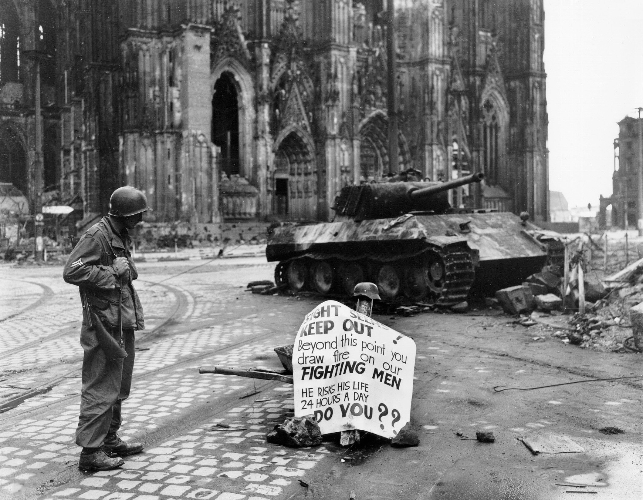
Oorspronkelijk bestand (2.119 × 1.649 pixels, bestandsgrootte: 920 kB, MIME-type: image/jpeg)
Dit is een bestand van Wikimedia Commons. Onderstaande beschrijving komt van de beschrijving van het bestand daar. Commons is een vrij-gelicenceerde database voor afbeeldingen, geluid, video en andere bestanden. |
|

Deze afbeelding is geselecteerd als afbeelding van de dag op 30 mei 2006. De afbeelding heeft de volgende beschrijving: English: A Cpl. of 82nd Airborne Division reads a warning sign in the street Cologne, Germany, 4 April 1945. Andere talen: Bahasa Melayu: Seorang Korporal dari 82nd Airborne Division membaca sebuah tanda amaran di jalan Cologne, Jerman, 4 April 1945. Català: Un soldat americá mira un cartell davant la catedral de Colonia Čeština: Voják čtoucí varování, Kolín nad Rýnem, Německo, 4. dubna 1945 Cymraeg: Milwr Americanaidd yn darllen arwydd o rybudd o yng Nghwlen (Cologne), yr Almaen, 4ydd o Ebrill 1945. Dansk: En amerikansk korporal i 82nd Airborne Division læsende et advarselsskilt i Köln, 4. april 1945. Deutsch: Ein Korporal der 82nd Airborne Division der U.S. Armee liest ein Warnschild auf der Straße; Köln, Deutschland, 4. April 1945. English: A Cpl. of 82nd Airborne Division reads a warning sign in the street Cologne, Germany, 4 April 1945. Español: Un soldado americano lee un cartel ante la catedral de Colonia Français : Un caporal de la U.S. 82nd Airborne Division (82e division aéroportée américaine) lisant un avertissement dans une rue de Cologne, Allemagne, le 4 avril 1945 Galego: Un cabo da 82 División Aerotransportada le un aviso nunha rúa de Colonia, Alemaña, 4 de abril de 1945. Lëtzebuergesch: E Kaperol vun der 82nd Airborne Division vun der U.S. Arméi liest e Warnschëld op enger Strooss zu Köln, Däitschland, 4. Abrëll 1945. Polski: Kapral 82 dywizji powietrzno-desantowej czyta napis ostrzegawczy na ulicy Kolonii. Niemcy, 4 kwietnia 1945. Português: Um soldado americano lendo um cartaz diante da catedral de Colônia, Alemanha em 4 de abril de 1945. Suomi: Alikersantti 82. maahanlaskudivisioonasta, tunnettu myös nimellä "All-Americas", lukee varoituskylttiä Kölnissä, Saksassa, 4. huhtikuuta 1945 Svenska: En amerikansk soldat läser en varningsskylt på en gata i Köln den 4 april 1945. العربية : كولن، ألمانيا، 4 أبريل 1945. |
This image was selected as picture of the day on Vietnamese Wikipedia. |
Beschrijving
| Beschrijving | English: Original caption: Cologne, Germany - Cpl. Luther E. Boger, Concord, N.C., skytrooper, reads a warning sign in the street. This street leads to the Rhine River and is under observation of the Germans who occupy a stronghold there. Cpl. Boger is with the 82nd Airborne Division. 4 April 1945. The German tank is burnt out and the torsion-bars have been destroyed by the immense heat of the fire.
|
| Datum | Genomen op 4 april 1945 |
| Bron | US-Army history images (jpeg) |
| Auteur | Post processing by User:W.wolny |
| Andere versies |
.jpg)
| Cameralocatie | | Deze en andere afbeeldingen in: OpenStreetMap |
|---|
Licentie
Deze afbeelding is een werk van een soldaat of werknemer van de U.S. Army, genomen of gemaakt tijdens de uitvoering van diens officiële taken. Als werk van de federale overheid van de Verenigde Staten bevindt deze afbeelding zich in het publiek domein.
|  |
Bestandsgeschiedenis
Klik op een datum/tijd om het bestand te zien zoals het destijds was.
| Datum/tijd | Miniatuur | Afmetingen | Gebruiker | Opmerking | |
|---|---|---|---|---|---|
| huidige versie | 20 apr 2005 13:16 | | 2.119 × 1.649 (920 kB) | W.wolny |
Bestandsgebruik
Geen enkele pagina gebruikt dit bestand.
Globaal bestandsgebruik
Dit bestand wordt op de volgende andere wiki’s gebruikt:
- Gebruikt op ar.wikipedia.org
- Gebruikt op az.wikipedia.org
- Gebruikt op bg.wikipedia.org
- Gebruikt op ca.wikipedia.org
- Gebruikt op cs.wikipedia.org
- Gebruikt op da.wikipedia.org
- Gebruikt op de.wikipedia.org
- Gebruikt op de.wiktionary.org
- Gebruikt op el.wikipedia.org
- Gebruikt op en.wikipedia.org
- Gebruikt op es.wikipedia.org
- Gebruikt op eu.wikipedia.org
- Gebruikt op fi.wikipedia.org
- Gebruikt op fr.wikipedia.org
- Gebruikt op fy.wikipedia.org
- Gebruikt op he.wikipedia.org
- Gebruikt op hi.wikipedia.org
- Gebruikt op hu.wikipedia.org
- Gebruikt op hy.wikipedia.org
- Gebruikt op hyw.wikipedia.org
- Gebruikt op ia.wikipedia.org
- Gebruikt op id.wikipedia.org
Globaal gebruik van dit bestand bekijken.
Explore the world

United states
New York

Japan
Tokyo

Singapore
Singapore
