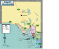
Size of this PNG preview of this SVG file: 720 × 600 pixels. Other resolutions: 288 × 240 pixels | 576 × 480 pixels | 922 × 768 pixels | 1,229 × 1,024 pixels | 2,458 × 2,048 pixels | 750 × 625 pixels.
Original file (SVG file, nominally 750 × 625 pixels, file size: 9.37 MB)
File history
Click on a date/time to view the file as it appeared at that time.
| Date/Time | Thumbnail | Dimensions | User | Comment | |
|---|---|---|---|---|---|
| current | 13:28, 25 June 2023 |  | 750 × 625 (9.37 MB) | SHB2000 | {{Information |Description=A map of {{w|South Australia}} with its regions used on its respective Wikivoyage article. |Source={{own}}, except for * Boundaries: File:Australia South Australia map.png * Outline: OpenStreetMap |Date=202306-25 |Author=SHB2000 |Permission= |other_versions=PNG file }} Category:Travel maps of Australia Category:Wikivoyage maps of South Australia by SHB2000 [[Category:M... |
File usage
There are no pages that use this file.
Global file usage
The following other wikis use this file:
- Usage on to.wikipedia.org


 Français
 Italiano


